Subscribe to our newsletter today
Lorem ipsum dolor sit amet consectetur adipiscing eli mattis sit phasellus mollis sit aliquam sit nullam.
crater-lake-three-sisters-bend-rv-guide
Venenatis sollicitudin posuere elit consequat et enim. Neque tortor amet dictum tempor. Leo facilisis aliquet viverra scelerisque eleifend viverra est. At massa erat vel amet enim laoreet dictum pellentesque. Urna cursus quam pulvinar tellus. Duis fermentum nibh volutpat morbi. Et ac sed ultricies ut nunc sodales lectus.
Et urna ac et maecenas fusce amet. Nibh nec commodo massa sed. Tincidunt porttitor in pharetra egestas sit neque ac lacus. Amet a nunc et cum. Odio at volutpat volutpat in leo eget ipsum diam elementum. Erat magna arcu orci lorem senectus orci fringilla. Tincidunt metus nisl vitae maecenas pretium aliquet.
Quis faucibus massa sit egestas. Sit fermentum est ac pulvinar et sagittis sed sit ut. Quis faucibus aenean nibh vestibulum enim mi sit. Sollicitudin ultrices ultrices in ipsum urna fringilla massa leo. Sapien ultricies vitae rhoncus molestie purus. Urna urna dolor euismod porttitor et. Magna adipiscing dictum et adipiscing mollis feugiat.

Quis faucibus massa sit egestas. Sit fermentum est ac pulvinar et sagittis sed sit ut. Quis faucibus aenean nibh vestibulum enim mi sit. Sollicitudin ultrices ultrices in ipsum urna fringilla massa leo. Sapien ultricies vitae rhoncus molestie purus. Urna urna dolor euismod porttitor et. Magna adipiscing dictum et adipiscing mollis feugiat.
Cursus curabitur euismod vel fermentum sapien non dolor odio vel. Tortor lectus mauris in praesent a tincidunt nam. In aenean odio aliquet pretium viverra elit quis magna. Eget ut risus posuere velit purus nisi nec sollicitudin. Tellus enim interdum neque sit vestibulum lacus. Nam pulvinar a lectus justo aliquet integer amet.
“Sed id mi eget urna facilisis pharetra nunc viverra est at magna maximus consectetur sed nec maximus augue aliquam commodo sem eu.”
Cursus curabitur euismod vel fermentum sapien non dolor odio vel. Tortor lectus mauris in praesent a tincidunt nam. In aenean odio aliquet pretium viverra elit quis magna. Eget ut risus posuere velit purus nisi nec sollicitudin. Tellus enim interdum.
Sed non quis tellus velit orci. Quam sed mauris elementum tempor viverra. Luctus semper risus ipsum id diam praesent. Pretium eget mauris ultrices curabitur sed sem amet. Erat nulla habitant in mattis massa mi adipiscing ullamcorper condimentum. Erat quisque integer tincidunt ac amet tempor vulputate tristique.
Sed non quis tellus velit orci. Quam sed mauris elementum tempor viverra. Luctus semper risus ipsum id diam praesent. Pretium eget mauris ultrices curabitur sed sem amet. Erat nulla habitant in mattis massa mi adipiscing ullamcorper condimentum. Erat quisque integer tincidunt ac amet tempor vulputate tristique.
Sed non quis tellus velit orci. Quam sed mauris elementum tempor viverra. Luctus semper risus ipsum id diam praesent. Pretium eget mauris ultrices curabitur sed sem amet. Erat nulla habitant in mattis massa mi adipiscing ullamcorper condimentum.
Central Oregon is the part of the state most visitors miss. They drive the coast, they fly into Portland, they skip the interior. That's a mistake. The high desert east of the Cascades contains some of the most dramatic and varied landscape in the Pacific Northwest — a 1,943-foot deep volcanic lake that holds the bluest water you've ever seen, three glacier-covered volcanic peaks rising above ancient lava fields, a river canyon that draws rock climbers from around the world, and a small city that has quietly become one of the best outdoor basecamp towns in the American West.
Give this part of Oregon the time it deserves.
The route
Bend → Smith Rock State Park → Three Sisters Wilderness → Newberry Volcanic National Monument → Crater Lake National Park → back to Bend via Highway 97
Total driving distance: approximately 300 miles as a loop from Bend. Recommended time: 5–7 days minimum. A full week lets you do it right.
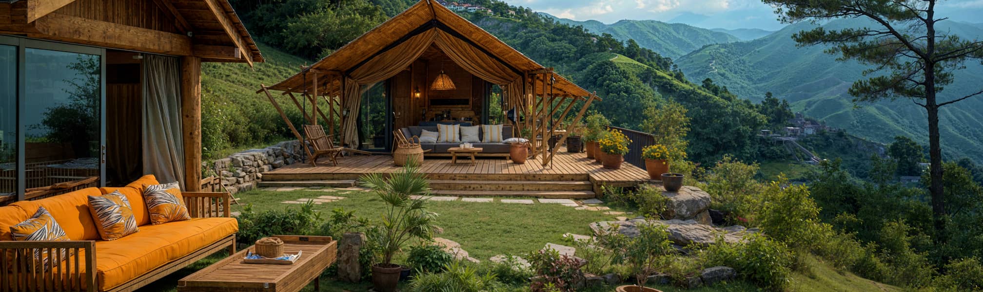
Bend is the natural basecamp for all of it — centrally located, well-supplied, and worth two days on its own before you start exploring the surrounding country.
Bend — The best basecamp town in Oregon
Bend sits on the eastern slope of the Cascades at 3,600 feet where the high desert meets the mountains. The Deschutes River runs through the middle of town. The Three Sisters are visible on the western horizon on clear days. The food scene, brewery culture, and outdoor recreation options are genuinely exceptional for a city of 100,000 people.
Plan at least two nights in Bend before heading out to the parks and wilderness areas. The town rewards time.
The Deschutes River Trail
A paved and natural surface trail running 12 miles along the Deschutes River through town and into the surrounding canyon. Accessible for all fitness levels, beautiful in every season, and the best way to understand the geography of Bend on foot. The whitewater section through Bend Whitewater Park in the middle of town is excellent for watching kayakers on the manufactured waves.
Old Mill District
A redeveloped historic lumber mill on the Deschutes River with restaurants, shops, and a REI flagship store. The river views from the district are excellent and the area is walkable from downtown. Good evening destination after a day in the field.
The Bend Ale Trail
Bend has more craft breweries per capita than almost any city in the country. Deschutes Brewery — the largest craft brewery in the Pacific Northwest — is the anchor, but the surrounding breweries are worth exploring. Boneyard Beer, Crux Fermentation Project, and Sunriver Brewing all make excellent beer and have comfortable taprooms. Walking the ale trail over two evenings is a legitimate Bend activity.
Sunriver Resort
15 miles south of Bend, Sunriver is a full-service resort community with RV accommodations, golf courses, a marina on the Deschutes River, and direct access to the Cascade Lakes Highway. A good base for families who want resort amenities with outdoor access.
Book on Campspot → [affiliate link]
Camping in Bend:
Tumalo State Park — just north of Bend on the Deschutes River. Full hookups, excellent facilities, and the best state park campground in the immediate Bend area. Book well in advance for summer.
Book on Reserve America → [affiliate link]
Bend/Sisters Garden RV Resort — full hookups, large pull-through sites, close to town amenities.
Book on Campspot → [affiliate link]
Smith Rock State Park
Smith Rock sits 25 miles north of Bend in the high desert — a dramatic canyon carved by the Crooked River through volcanic tuff, with spires and walls rising 800 feet from the canyon floor. It's one of the birthplaces of American sport climbing and still one of the premier rock climbing destinations in the country. Even if you don't climb, the hiking and scenery make it one of the best state parks in Oregon.
Getting there with an RV
The park entrance is well-signed from Highway 97 near Terrebonne. The access road handles most RV sizes. Day use parking is available — there is no overnight camping inside the park itself but bivouac camping is allowed in a designated area for foot traffic only. Most RVers base camp in Bend or at the private campground adjacent to the park.
Misery Ridge and River Trail Loop Difficulty: Strenuous Distance: 3.7 miles loop
The essential Smith Rock hike. The River Trail follows the Crooked River along the canyon floor with views of the climbing walls above — Monkey Face, Morning Glory Wall, and the Christian Brothers formation tower overhead. The Misery Ridge trail climbs steeply to the ridge above with panoramic views of the Three Sisters, Mount Jefferson, and the surrounding high desert. The loop descends back to the canyon floor through a different route.
Misery Ridge earns its name — 600 feet of elevation gain in 0.6 miles on loose volcanic rock. The views from the top are worth every step.
Monkey Face
The most iconic formation in Smith Rock — a 350-foot tower with a natural cave near the summit that resembles a monkey's face from the canyon floor. One of the most photographed rock formations in Oregon. Climbers on the routes up the face are visible from the trail below throughout the day.
Climbing at Smith Rock
Smith Rock has over 1,800 climbing routes on basalt and tuff walls ranging from beginner to 5.14. The park is credited with helping establish sport climbing in the United States in the 1980s — routes on Monkey Face and Morning Glory Wall are climbing history. Rent gear and hire guides from Smith Rock Climbing Guides in Terrebonne.
The Golden Hour
Smith Rock at sunset turns the volcanic tuff from brown to deep orange to red as the light drops. The canyon floor fills with shadow while the spires above stay lit. Plan to be at the Canyon Overlook viewpoint — a short walk from the parking area — in the last hour of daylight. It's one of the great evening views in Oregon.
Camping near Smith Rock:
Skull Hollow Campground — BLM dispersed camping area near Smith Rock with basic facilities and excellent high desert scenery. First-come-first-served.
Crooked River Ranch RV Park — full hookups near Terrebonne, close to Smith Rock.
Book on Campspot → [affiliate link]
Three Sisters Wilderness
The Three Sisters are three volcanic peaks — North Sister, Middle Sister, and South Sister — rising to over 10,000 feet above the Cascade crest west of Bend. The surrounding wilderness area contains ancient lava flows, alpine lakes, old-growth forest, and some of the best hiking in Oregon.
South Sister — The accessible summit
At 10,358 feet South Sister is the third highest peak in Oregon and the most commonly climbed. The standard route from Devils Lake trailhead is a non-technical hike — steep, long, and requiring good fitness but no climbing equipment. The summit offers views of all three sisters, Mount Jefferson, Mount Hood, and on clear days Mount Rainier to the north.
Distance: 11 miles round trip Elevation gain: 4,900 feet Difficulty: Strenuous
Start early — summit weather deteriorates in the afternoon. Bring layers regardless of the forecast at the trailhead. Snow on the upper mountain is possible through July and patches remain year-round on the north face.
Green Lakes Trail Difficulty: Moderate Distance: 9 miles round trip
One of the most popular and most beautiful trails in the Three Sisters Wilderness. The trail follows Fall Creek through old-growth forest past multiple waterfalls before opening into the Green Lakes basin — three emerald lakes at the base of the South Sister and Broken Top with views of the surrounding volcanic peaks. The wildflower display in late July and August in the basin is exceptional.
Tam McArthur Rim Difficulty: Moderate to strenuous Distance: 5 miles round trip
From Three Creek Lake trailhead south of Sisters, a trail climbs to a volcanic rim at 7,700 feet with views down into the Three Creek Lake basin and across to the Three Sisters. One of the best viewpoint hikes in central Oregon with less foot traffic than the South Sister routes.
Proxy Falls Difficulty: Easy Distance: 1.6 miles loop
Two waterfalls — Upper Proxy and Lower Proxy — reached by a short loop trail off Highway 242 (McKenzie Pass Highway). Lower Proxy Falls drops 200 feet into a lava basin where the water disappears into the porous volcanic rock rather than forming a pool. One of the most unusual waterfall experiences in Oregon.
The Lava Fields
Central Oregon sits on one of the most volcanically active landscapes in the lower 48. The Cascades are a chain of active volcanoes and the high desert around Bend is covered in lava flows ranging from a few thousand to several million years old. The scale and variety of the volcanic landscape is extraordinary — and largely overlooked by visitors focused on the coast and the mountains.
McKenzie Pass — Highway 242
The McKenzie Pass Highway crosses the Cascades through a landscape of recent lava flows — the most dramatic high-mountain lava scenery accessible by road in Oregon. The Dee Wright Observatory at the summit is a stone structure built by the Civilian Conservation Corps in 1935 sitting directly on the lava field with windows aligned to frame views of the surrounding volcanic peaks.
The highway is closed to vehicles over 35 feet and to trailers. Leave the rig in Sisters or Bend and drive the pass in your tow vehicle. The 37-mile road from Sisters to McKenzie Bridge is one of the best drives in Oregon.
Lava Lands Visitor Center and Lava Butte
A Newberry Volcanic National Monument site south of Bend. Lava Butte is a 500-foot cinder cone with a paved road to the summit — from the top the lava flow that erupted from its base 7,000 years ago extends in every direction across the high desert. The visitor center below has excellent interpretation of the volcanic geology of central Oregon.
RV note: The road to the Lava Butte summit has size restrictions — check current limits at the visitor center. Most rigs base camp below and drive to the summit in a tow vehicle.
Lava River Cave
A 1-mile long lava tube cave south of Bend — the longest uncollapsed lava tube in Oregon. Lantern rentals available at the entrance. The cave maintains a constant 42°F year-round — bring a jacket regardless of the outside temperature. Walking through a lava tube formed by a volcanic eruption thousands of years ago is a genuinely unusual experience. RV-friendly parking at the trailhead.
Newberry Volcanic National Monument
Newberry Volcano is a shield volcano covering 500 square miles south of Bend — one of the largest volcanoes in the Cascades. The caldera at the summit contains two lakes — Paulina Lake and East Lake — and the obsidian flow on the caldera rim is one of the largest and youngest obsidian flows in the United States.
Paulina Peak — the high point of the Newberry caldera at 7,985 feet. A paved road climbs to the summit with panoramic views of the caldera lakes, the Three Sisters, and the surrounding high desert. One of the great viewpoint drives in central Oregon — the view from the top on a clear day extends 100 miles in every direction.
Big Obsidian Flow — a 1,300-year-old obsidian flow on the caldera rim. A 0.9-mile interpretive trail crosses the flow — you walk across jet-black volcanic glass formed in one of the most recent volcanic eruptions in Oregon. The contrast of the black obsidian against the blue sky and the distant peaks is extraordinary. One of the most unusual short hikes in the state.
Paulina Falls — a waterfall on Paulina Creek at the caldera rim with views across the caldera to the lakes below. Short walk from the trailhead. Worth combining with the obsidian flow trail.
Camping at Newberry:
Paulina Lake Campground — inside the caldera on the shore of Paulina Lake. Some of the most unusual camping in Oregon — inside a volcanic caldera with fishing, kayaking, and hiking out the door. Electric hookups on some sites.
Book on Recreation.gov → [affiliate link]
East Lake Campground — on the eastern caldera lake with excellent fishing for brown and rainbow trout. More remote than Paulina Lake with a different character.
Book on Recreation.gov → [affiliate link]
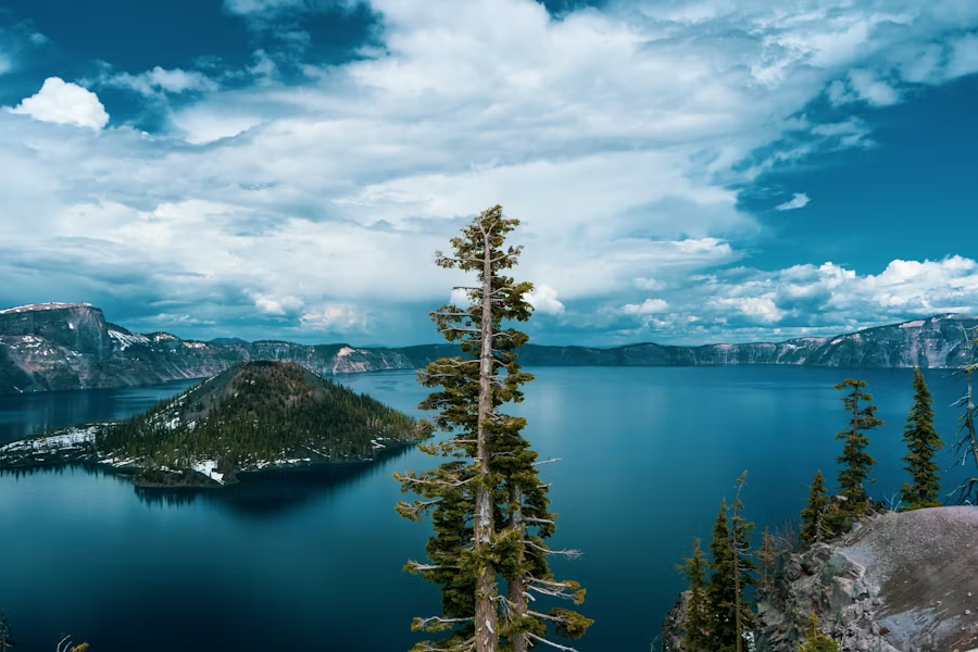
Crater Lake National Park
Crater Lake is the deepest lake in the United States at 1,943 feet and holds some of the clearest and most intensely blue water on earth. The lake sits inside the caldera of Mount Mazama — a volcano that erupted catastrophically 7,700 years ago and collapsed into itself, leaving a bowl that filled with snowmelt and rain over thousands of years.
No rivers flow into or out of Crater Lake. The water is so pure it has a Secchi depth — the measure of water clarity — of over 100 feet. The blue color comes from the depth and purity of the water absorbing all wavelengths of light except blue.
Nothing completely prepares you for the first view of it.
Getting there with an RV
Crater Lake is about 90 miles south of Bend via Highway 97 and Highway 62. The park road — Rim Drive — circles the caldera at 7,100 feet and is paved and well-maintained. The road handles most RVs with some pullouts that are tight for very long rigs.
The park road typically opens in late June — the rim receives 44 feet of snow per year and the road is plowed in spring. Check current road conditions at nps.gov/crla before your visit.
Rim Drive
The 33-mile loop around the caldera rim is the primary experience at Crater Lake. Every pullout delivers a different angle on the lake and the surrounding caldera walls. Plan 3–4 hours for the full loop with stops — more if you're hiking.
Key viewpoints on the rim:
Rim Village — the main developed area on the south rim. The historic Crater Lake Lodge sits on the rim edge with views of the lake from the lobby and the front porch. Non-guests can walk the grounds — the porch view of the lake with a cup of coffee in the morning is worth the stop.
Discovery Point — the viewpoint closest to where John Wesley Hillman first saw the lake in 1853 and described it as "the bluest lake I ever saw." The name is earned.
Watchman Peak — a short steep hike from a pullout on the west rim to a historic fire lookout tower with the best panoramic view of the entire caldera. 1.6 miles round trip with 420 feet of elevation gain. One of the best hikes in the park.
Cloudcap Overlook — the highest point on Rim Drive at 7,960 feet with views across the lake to Wizard Island and the western caldera wall. The view of the deep blue lake from this elevation is extraordinary.
Wizard Island
A cinder cone rising 763 feet above the lake surface — the only land visible on the lake. Boat tours from Cleetwood Cove on the north rim run to Wizard Island from late June through early September. The tour includes time on the island for hiking to the summit crater and swimming in the lake.
Swimming in Crater Lake is permitted — the water is an extremely cold 55°F at the surface in summer. The clarity is unlike any lake you've swum in. Cleetwood Cove is the only spot where you can access the lake shore — a 1.1-mile steep trail descends to the cove.
Book boat tours at recreation.gov → [affiliate link]
Cleetwood Cove Trail Difficulty: Strenuous Distance: 2.2 miles round trip
The only trail that descends to the lake shore. Steep — 700 feet of elevation loss in 1.1 miles — with the knowledge that every foot down is a foot you climb back up on the return. The lake from the water's edge looks different from the rim — deeper, more immediate, more extraordinary. Worth doing at least once.
The Pinnacles
A 7-mile spur road from the southeast rim leads to a canyon filled with volcanic spires — pinnacles of hardened volcanic rock formed when gases escaped through the ash layer after the Mount Mazama eruption. An unusual and little-visited section of the park with dramatic geology and almost no crowds.
Sunrise and sunset
The lake changes color continuously through the day — deepest blue in the middle hours, shifting to purple and gold at the edges during golden hour. Sunrise on the east rim when the first light hits the lake is genuinely extraordinary. Sunset from the Watchman overlook is equally good. Plan at least one early morning at the rim.
Stargazing
Crater Lake's high elevation and remote location make it one of the better dark sky locations in Oregon. The park runs ranger-led astronomy programs in summer. On a clear night the Milky Way is visible with the naked eye from the rim — the combination of the stars and the black mirror of the lake below is one of the great night sky experiences in the Pacific Northwest.
Where to camp:
Mazama Campground — the main campground inside the park near the south entrance. Full hookups on some sites, electric on others. Books up well in advance on Recreation.gov for summer weekends. The most convenient base for Rim Drive and the main visitor areas.
Book on Recreation.gov → [affiliate link]
Lost Creek Campground — a smaller tent-only campground on the east side of the park near the Pinnacles. First-come-first-served. No hookups — for self-contained rigs only.
Practical notes for central Oregon
Altitude matters throughout. Bend sits at 3,600 feet. Crater Lake rim is at 7,100 feet. South Sister summit is over 10,000 feet. The altitude affects exertion more than most visitors expect — pace yourself on the first day at elevation and drink more water than usual.
Summer is the window for everything. The McKenzie Pass highway doesn't open until June. Crater Lake Rim Drive typically opens in late June. South Sister is safest in July and August. Plan your visit for July through September for reliable access to all areas.
Wildfire smoke is a real possibility. Central and southern Oregon has significant fire activity in late summer — August and September can bring smoke that reduces visibility dramatically. Check air quality forecasts at airnow.gov and have a flexible itinerary if smoke moves in.
Cell service east of the Cascades is better than the coast but drops out in the wilderness areas and inside Crater Lake. Starlink handles Bend and the high desert well.
Sunriver and Bend have full services. Stock provisions and fill your propane in Bend before heading to Newberry or Crater Lake — services thin out significantly once you leave the city.
Gear for central Oregon
Bottom Line
Start in Bend. Give it two nights. Drive to Smith Rock for the afternoon golden hour. Hike the Green Lakes trail to the Three Sisters basin on your best weather day. Walk through the lava tube at night. Drive McKenzie Pass without the rig. Stand on the rim of Crater Lake at sunrise.
Central Oregon rewards the visitor who comes without a rushed itinerary. The landscape is varied enough that no two days feel the same — volcanic desert in the morning, alpine wilderness in the afternoon, the deepest blue lake in the country at golden hour. It's one of the most underrated regions in the American West.
Related reading
Combining central Oregon with the coast? See our full Oregon Coast road trip guide.
The Ultimate Oregon Coast RV Road Trip →
Lorem ipsum dolor sit amet consectetur adipiscing eli mattis sit phasellus mollis sit aliquam sit nullam.