Subscribe to our newsletter today
Lorem ipsum dolor sit amet consectetur adipiscing eli mattis sit phasellus mollis sit aliquam sit nullam.
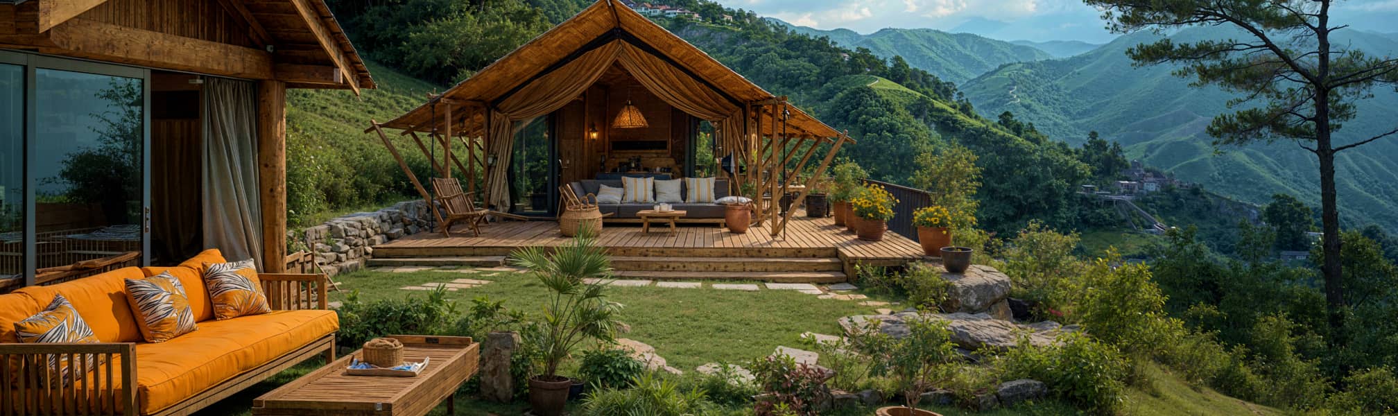
Highway 395 Eastern Sierra RV road trip — Alabama Hills, Mount Whitney, Bishop, Mammoth Lakes, June Lake Loop, Mono Lake, Bodie Ghost Town, and Bridgeport with campground recommendations and practical tips.
Venenatis sollicitudin posuere elit consequat et enim. Neque tortor amet dictum tempor. Leo facilisis aliquet viverra scelerisque eleifend viverra est. At massa erat vel amet enim laoreet dictum pellentesque. Urna cursus quam pulvinar tellus. Duis fermentum nibh volutpat morbi. Et ac sed ultricies ut nunc sodales lectus.
Et urna ac et maecenas fusce amet. Nibh nec commodo massa sed. Tincidunt porttitor in pharetra egestas sit neque ac lacus. Amet a nunc et cum. Odio at volutpat volutpat in leo eget ipsum diam elementum. Erat magna arcu orci lorem senectus orci fringilla. Tincidunt metus nisl vitae maecenas pretium aliquet.
Quis faucibus massa sit egestas. Sit fermentum est ac pulvinar et sagittis sed sit ut. Quis faucibus aenean nibh vestibulum enim mi sit. Sollicitudin ultrices ultrices in ipsum urna fringilla massa leo. Sapien ultricies vitae rhoncus molestie purus. Urna urna dolor euismod porttitor et. Magna adipiscing dictum et adipiscing mollis feugiat.

Quis faucibus massa sit egestas. Sit fermentum est ac pulvinar et sagittis sed sit ut. Quis faucibus aenean nibh vestibulum enim mi sit. Sollicitudin ultrices ultrices in ipsum urna fringilla massa leo. Sapien ultricies vitae rhoncus molestie purus. Urna urna dolor euismod porttitor et. Magna adipiscing dictum et adipiscing mollis feugiat.
Cursus curabitur euismod vel fermentum sapien non dolor odio vel. Tortor lectus mauris in praesent a tincidunt nam. In aenean odio aliquet pretium viverra elit quis magna. Eget ut risus posuere velit purus nisi nec sollicitudin. Tellus enim interdum neque sit vestibulum lacus. Nam pulvinar a lectus justo aliquet integer amet.
“Sed id mi eget urna facilisis pharetra nunc viverra est at magna maximus consectetur sed nec maximus augue aliquam commodo sem eu.”
Cursus curabitur euismod vel fermentum sapien non dolor odio vel. Tortor lectus mauris in praesent a tincidunt nam. In aenean odio aliquet pretium viverra elit quis magna. Eget ut risus posuere velit purus nisi nec sollicitudin. Tellus enim interdum.
Sed non quis tellus velit orci. Quam sed mauris elementum tempor viverra. Luctus semper risus ipsum id diam praesent. Pretium eget mauris ultrices curabitur sed sem amet. Erat nulla habitant in mattis massa mi adipiscing ullamcorper condimentum. Erat quisque integer tincidunt ac amet tempor vulputate tristique.
Sed non quis tellus velit orci. Quam sed mauris elementum tempor viverra. Luctus semper risus ipsum id diam praesent. Pretium eget mauris ultrices curabitur sed sem amet. Erat nulla habitant in mattis massa mi adipiscing ullamcorper condimentum. Erat quisque integer tincidunt ac amet tempor vulputate tristique.
Sed non quis tellus velit orci. Quam sed mauris elementum tempor viverra. Luctus semper risus ipsum id diam praesent. Pretium eget mauris ultrices curabitur sed sem amet. Erat nulla habitant in mattis massa mi adipiscing ullamcorper condimentum.
Highway 395 is the best road trip in California that most people outside the state have never heard of. It runs 200 miles along the eastern base of the Sierra Nevada from Lone Pine in the south to Bridgeport in the north — with the highest mountain in the lower 48 on one side and the Great Basin desert stretching east to Nevada on the other.
The landscape changes every 30 miles. Alabama Hills movie location rock formations give way to the highest peak in the contiguous United States, which gives way to the resort town of Mammoth Lakes, which gives way to the ancient volcanic landscape around Mono Lake, which gives way to gold rush ghost towns and the jagged granite peaks of the Bridgeport Valley.
It's one drive. All of it extraordinary.
The route
Lone Pine → Alabama Hills → Mount Whitney → Bishop → Mammoth Lakes → June Lake Loop → Mono Lake → Lee Vining → Bodie Ghost Town → Bridgeport
Total driving distance: approximately 200 miles on Highway 395. Recommended time: 5–7 days. A week lets you do it right.
Drive it south to north for the best approach — the Alabama Hills and Mount Whitney set the tone and the landscape builds from there. Most people start from Los Angeles via Highway 14 north to 395 — about 3.5 hours to Lone Pine.
Lone Pine — The southern anchor
Lone Pine is a small desert town at 3,700 feet with one of the most dramatic backdrops of any town in California — Mount Whitney rising to 14,505 feet directly to the west, visible from the main street on clear days. The town has been a movie location since the silent film era — over 400 films have been shot in the surrounding Alabama Hills.
Lone Pine Film History Museum — a surprisingly excellent museum documenting the town's century of film history. John Wayne, Gary Cooper, Roy Rogers, and Gene Autry all filmed here. The collection of film stills, props, and equipment is extensive and the context for what you'll see in the Alabama Hills is useful. Free with a donation requested.
Eastern Sierra Interagency Visitor Center — just south of town on Highway 395. The best visitor center on the entire 395 corridor — comprehensive information on Mount Whitney permits, Alabama Hills, Death Valley, and the surrounding desert. Stop here first before doing anything else in the area.
Camping near Lone Pine:
Lone Pine Campground — a Forest Service campground at 6,000 feet on the Whitney Portal Road above town. No hookups. Good base for Alabama Hills access and Whitney Portal day trips.
Book on Recreation.gov → [affiliate link]
Boulder Creek RV Resort — full hookups in Lone Pine. The most practical base camp for RVers exploring the area.
Book on Campspot → [affiliate link]
Alabama Hills
The Alabama Hills are a field of rounded granite and metamorphic rock formations at the base of the Sierra Nevada west of Lone Pine — weathered into domes, arches, and boulders by millions of years of erosion. The contrast between the warm brown rocks in the foreground and the sharp white granite peaks of the Sierra rising immediately behind them is one of the most dramatic landscape compositions in the American West.
John Ford, Clarence Brown, and dozens of other directors discovered this in the 1920s and the area has been continuously used as a film location ever since. If you've seen a western, a war film, or a science fiction movie set in a dramatic rocky desert, there's a good chance it was filmed here.
Movie Road
An unpaved road through the heart of the Alabama Hills past the most famous filming locations. Most passenger cars handle it without issue. Most RVs should park at the Tuttle Creek area and use a tow vehicle — Movie Road has some narrow sections and soft shoulders.
Mobius Arch
The most photogenic arch in the Alabama Hills — a natural stone window perfectly framing Mount Whitney and the Sierra crest behind it. A 1-mile round trip walk from the parking area on Movie Road. The classic composition is Mobius Arch in the foreground with Whitney rising through the frame at sunrise. One of the great photography spots in California.
Sunrise and sunset in the Alabama Hills
The warm light on the rounded brown boulders at golden hour against the cold white of the Sierra peaks is extraordinary in both directions. Arrive before dawn for the Mobius Arch composition. Stay for sunset from any open area with a westward view.
The Alabama Hills are BLM land — dispersed camping is permitted throughout except in designated no-camping zones. For RVers, dispersed camping in the hills is one of the great free camping experiences in California. Check current restrictions at the Lone Pine visitor center.
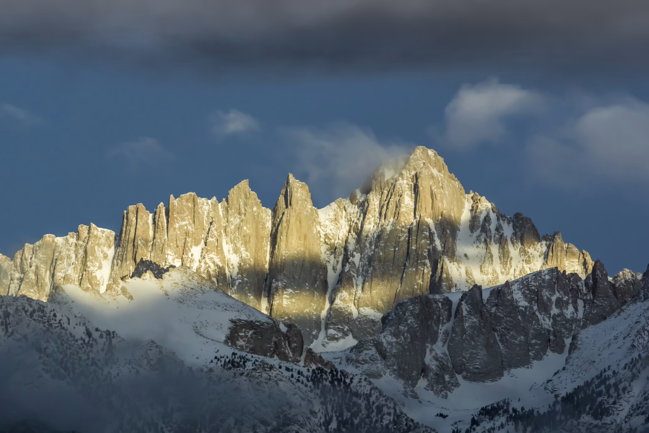
Mount Whitney
At 14,505 feet Mount Whitney is the highest peak in the contiguous United States. The standard route from Whitney Portal is 22 miles round trip with 6,100 feet of elevation gain — a serious undertaking that typically requires an overnight permit and camping near the summit.
The view from the summit on a clear day takes in the Sierra Nevada stretching 200 miles in both directions, the Great Basin desert dropping away to the east, and on exceptional days the curve of the earth visible at the horizon.
Whitney Portal
The road from Lone Pine climbs 13 miles and 4,000 feet to Whitney Portal at 8,365 feet — the trailhead for the summit and the lower trailhead for the Mount Whitney Trail. The drive alone is worth doing for the views back across the Owens Valley and the Alabama Hills below.
Whitney Portal Store — a historic trailhead store with supplies, hot food, and the best pancakes at elevation you'll find anywhere. The pancakes have a cult following among Whitney summit hikers.
Day hiking from Whitney Portal
The lower Whitney Trail to Lone Pine Lake at 10,040 feet is a beautiful day hike that doesn't require a permit and delivers genuine alpine scenery — granite peaks, glacial lakes, and the upper Whitney drainage. 6 miles round trip with 1,600 feet of elevation gain.
The Whitney Zone permit system
Day hikes to the summit and overnight trips in the Whitney Zone require a permit — issued by lottery in February for the following season. The lottery is competitive for popular summer dates. Walk-up permits are available daily at the visitor center but go fast. Plan well in advance if summiting is your goal.
For RVers who want the Whitney experience without the permit lottery: the view from Whitney Portal and the lower trail hike deliver the scale and the scenery that most people come for. The summit is extraordinary but the mountain is extraordinary from a long way below it too.
Bishop — The heart of the Owens Valley
Bishop sits in the middle of the Owens Valley at 4,150 feet — the largest town on the 395 corridor and the best supply stop between Lone Pine and Mammoth. It has developed a legitimate food and outdoor culture centered around its position as basecamp for the surrounding climbing, fishing, and hiking.
Mahogany Smoked Meats
The best stop in Bishop and one of the best food stops on the entire 395 corridor. Mahogany Smoked Meats has been smoking meat in Bishop since 1922 — jerky, sausage, smoked turkey, and dried beef made from locally sourced meat using century-old recipes. The jerky is extraordinary and the shop smells like everything you want a small-town meat shop to smell like.
Get the peppered beef jerky. Get the garlic sausage. Get more than you think you need — it will be gone before Mammoth.
Erick Schat's Bakkery
A Bishop institution since 1938. The sheepherder bread — a round sourdough loaf baked in the traditional Basque style — is the thing. Lines form on weekend mornings and the bread sells out. Get there early. The pastry case is also excellent.
Bishop Creek Canyon
Highway 168 west of Bishop climbs into the Sierra to a series of lakes — South Lake, Lake Sabrina, and North Lake — at 9,000 to 10,000 feet with trailheads for the John Muir Wilderness. The canyon is also one of the best fly fishing destinations in California with excellent brown and rainbow trout in the creek and the lakes.
Laws Railroad Museum
A preserved narrow-gauge railroad depot and yard from the Carson and Colorado Railroad — the narrow-gauge line that served the Owens Valley from 1883 to 1960. The collection of historic equipment and buildings is surprisingly extensive and the setting — high desert with the Sierra visible to the west — is excellent. Free to visit.
Camping near Bishop:
Brown's Town Campground — a full-hookup private campground in Bishop. The best base camp for exploring the Owens Valley and Bishop Creek Canyon.
Book on Campspot → [affiliate link]
Bishop City Park Campground — city-operated campground with hookups. Convenient and affordable.
Sabrina Campground — a Forest Service campground at Lake Sabrina above Bishop at 9,000 feet. No hookups. Excellent for fishing and Sierra access.
Book on Recreation.gov → [affiliate link]
Mammoth Lakes
Mammoth Lakes is the premier mountain resort town on the eastern Sierra — a four-season destination at 8,000 feet with world-class skiing in winter, excellent hiking and mountain biking in summer, and fishing that draws anglers from across the state. The town is larger and more developed than anything else on the 395 corridor — full services, good restaurants, and a genuine resort infrastructure.
Devils Postpile National Monument
A formation of 60-foot basalt columns created when a lava flow cooled and fractured into remarkably regular hexagonal shapes — one of the finest examples of columnar basalt in the world. The monument sits in the Reds Meadow Valley accessible by shuttle from the Mammoth Mountain ski area.
The shuttle is mandatory from June through September — private vehicles are not permitted in the valley during peak season. Take the shuttle from the Mammoth Mountain Adventure Center.
Rainbow Falls — a 101-foot waterfall on the Middle Fork of the San Joaquin River accessible by a short trail from the Reds Meadow shuttle stop. The falls create rainbows in the mist on sunny afternoons. One of the best easily-accessible waterfalls in the Sierra.
Mammoth Mountain
The ski resort operates year-round — skiing and snowboarding from November through June in good snow years, mountain biking and scenic gondola rides in summer. The gondola to the 11,053-foot summit delivers panoramic views of the surrounding Sierra and Great Basin.
Convict Lake
A glacial lake 8 miles south of Mammoth at the base of dramatic Sierra peaks — one of the most scenic lakes on the entire 395 corridor. The loop trail around the lake is easy and flat with excellent views. Good fishing for brown and rainbow trout. The Convict Lake Resort restaurant is worth stopping for lunch.
Hot Creek Geological Site
A natural hot spring where geothermally heated water bubbles up into a creek creating a series of pools at various temperatures. Swimming was once permitted but is now prohibited due to unpredictable water temperatures — the site is worth visiting for the geology and the visual drama of steam rising from the creek in the high desert.
Mammoth Lakes Basin
A series of lakes — Twin Lakes, Lake Mary, Lake George, and Lake Mamie — in the mountains above town accessible by a paved road. Excellent fishing, hiking trailheads, and some of the best high-altitude camping in the Sierra. The Crystal Lake Trail from Lake George delivers excellent views for moderate effort.
Camping near Mammoth:
Twin Lakes Campground — a Forest Service campground at Twin Lakes above town. Some hookups. Excellent fishing access.
Book on Recreation.gov → [affiliate link]
Mammoth Mountain RV Park — full hookups at the ski area base. The most convenient full-hookup option in the area.
Book on Campspot → [affiliate link]
June Lake Loop
Highway 158 turns west off Highway 395 north of Mammoth and loops through the June Lake basin — four lakes in a glacially carved valley below the Carson Peak and the Sierra crest. The June Lake Loop is one of the most scenic short drives in the Sierra and one of the most consistently overlooked by visitors heading north to Mono Lake.
June Lake — the largest lake on the loop with a small resort town. Good fishing for rainbow and brown trout. The June Lake Marina rents boats and kayaks.
Silver Lake — the most dramatic lake on the loop with Rush Creek Falls visible on the hillside above. The Rush Creek Trail climbs from Silver Lake to Gem Lake and Waugh Lake in the John Muir Wilderness — excellent day hiking.
Grant Lake — at the northern end of the loop with views of the volcanic tablelands to the east and the Sierra to the west.
Fall color on the June Lake Loop — the aspens around the lakes turn gold in late September and early October. The combination of yellow aspen, blue lake, and Sierra granite is extraordinary. One of the best fall color destinations in California.
Camping on the June Lake Loop:
Oh! Ridge Campground — on June Lake with excellent views. Some hookups.
Book on Recreation.gov → [affiliate link]
Silver Lake Campground — at Silver Lake with Rush Creek Falls visible from the sites.
Book on Recreation.gov → [affiliate link]
Mono Lake
Mono Lake is one of the strangest and most beautiful landscapes in California — an ancient saline lake two and a half times saltier than the ocean, surrounded by volcanic craters and filled with otherworldly tufa towers rising from the water. The lake has no outlet — water flows in but doesn't flow out, concentrating salt and minerals over hundreds of thousands of years.
The tufa towers — calcium carbonate spires formed when freshwater springs bubbled up through the alkaline lake water — are the visual signature of Mono Lake. They were submerged for most of the lake's history and were exposed when the city of Los Angeles diverted the streams feeding the lake starting in 1941, dropping the lake level by 40 feet. A legal battle stretching over decades eventually forced partial restoration of the streams.
South Tufa Area
The best and most accessible tufa grove. A 1-mile trail loops through the towers along the lakeshore — the spires range from a few feet to 30 feet tall and the alkaline lake stretches behind them with the Sierra visible to the west. Sunset here is extraordinary — the warm light on the white tufa against the blue lake and the mountains creates a scene that looks like a science fiction landscape.
Entrance fee required — America the Beautiful pass accepted.
Navy Beach
A free swimming area on the south shore. Swimming in Mono Lake is a unique experience — the extremely high salt and mineral content makes you so buoyant it's difficult to sink. The water is silky from the carbonates and excellent for the skin. Rinse off thoroughly afterward — the minerals dry white on skin and clothing.
Mono Lake Tufa State Natural Reserve Visitor Center
In the town of Lee Vining on the northwest shore of the lake. Excellent interpretation of the lake's geology, ecology, and the water rights battle that nearly destroyed it. The staff are knowledgeable and passionate about the lake — worth spending an hour here before you walk the tufa.
Panum Crater
A volcanic crater on the north shore of Mono Lake — one of the youngest volcanoes in California at approximately 640 years old. A trail loops around the rim and into the crater with views of the lake and the surrounding volcanic landscape. One of the most accessible volcanic crater experiences in the state.
Bird watching
Mono Lake supports one of the largest nesting colonies of California gulls in the world — 50,000 birds nest on the lake's islands each spring. Millions of migratory shorebirds stop at the lake in late summer to feed on the brine shrimp and alkali flies that exist in extraordinary numbers in the alkaline water. For birders, Mono Lake in August is a serious destination.
Lee Vining
The small town on the northwest shore of Mono Lake is the gateway to Tioga Pass and the eastern entrance of Yosemite National Park. When Tioga Pass is open — typically late May through early November — Lee Vining is an excellent base for eastern Yosemite access without the valley crowds.
Camping near Mono Lake:
Lundy Canyon Campground — a Forest Service campground in beautiful Lundy Canyon north of Lee Vining. No hookups. Excellent fall color from the aspens in October.
Book on Recreation.gov → [affiliate link]
Lee Vining Creek Campground — multiple Forest Service campgrounds along Lee Vining Creek just south of town. No hookups. Good base for Mono Lake and Tioga Pass access.
Book on Recreation.gov → [affiliate link]
Bodie State Historic Park
Bodie is the best-preserved ghost town in the American West — a former gold rush boomtown that peaked at 10,000 residents in 1879 and was gradually abandoned as the gold ran out. The California State Parks maintains it in a state of "arrested decay" — nothing is restored, nothing is demolished. Buildings lean, wallpaper peels, bottles and cans rust on shelves exactly where they were left when the last residents walked away.
The effect is extraordinary. Walking through Bodie feels like arriving the day after everyone left.
Getting there
13 miles east of Highway 395 on a partially unpaved road — the last 3 miles are unpaved. Most RVs should park at the junction and drive in with a tow vehicle. The unpaved section is manageable in a passenger car or pickup but the road is rough enough to rattle loose connections on a larger rig.
What to see
The town contains over 100 buildings — the Methodist church, the Miner's Union Hall, the jail, the school, the Wheaton and Hollis Hotel, and dozens of homes and commercial buildings in various states of picturesque collapse. Guided tours are available from rangers during peak season and the self-guided walking tour covers the main buildings.
The cemetery on the hill above town has excellent views of the surrounding high desert and some of the most interesting headstones in California — the deaths recorded there telling the story of a violent and precarious boom town existence.
Go early morning or late afternoon. Midday in summer is hot and the tour buses arrive between 10am and 3pm. The light at golden hour on the weathered wood buildings is extraordinary.
No entrance fee beyond the standard state park day use fee. America the Beautiful pass not accepted — Bodie charges a separate California State Parks fee.
Bridgeport — The northern anchor
Bridgeport is a small ranching town at 6,500 feet in the Bridgeport Valley — a broad flat basin surrounded by mountains that looks like something from a classic western film. The Bridgeport Reservoir just north of town is one of the best fishing destinations on the entire 395 corridor.
Twin Lakes
10 miles west of Bridgeport in the mountains above town — two lakes in a glacially carved canyon below the Sawtooth Ridge. Excellent fishing for brown trout including some of the largest browns caught in California. The Annett's Mono Village Resort at the upper lake has RV hookups and a store.
Travertine Hot Springs
A free natural hot spring south of Bridgeport on BLM land — multiple pools at varying temperatures with views of the Sierra and the Bridgeport Valley. One of the best free hot spring experiences in California. Access via a short dirt road from Highway 395 — most passenger cars handle it but check current conditions.
The Bridgeport Inn — the best restaurant in the Bridgeport Valley. Steaks, burgers, and cold beer in a historic building on the main street. After a week on the road the Bridgeport Inn feels exactly right.
Camping near Bridgeport:
Bridgeport Reservoir Recreation Area — camping on the reservoir with good fishing access.
Book on Recreation.gov → [affiliate link]
Twin Lakes Campground — Forest Service campground at Twin Lakes above Bridgeport. Some hookups at Annett's Mono Village.
Book directly at monovillage.com →
Practical notes for Highway 395
Altitude throughout. The entire 395 corridor runs between 3,700 and 8,000 feet. Mammoth Lakes sits at 8,000 feet. The summit areas above are significantly higher. Drink more water than usual and pace yourself on the first day.
Services thin out north of Bishop. Stock fuel, food, and propane in Bishop or Mammoth before heading north. Lee Vining and Bridgeport have limited services at higher prices. There is nothing between Mammoth and Lee Vining on 395 proper.
Whitney permits book out months in advance. If summiting Mount Whitney is on your list, apply in the February lottery — walking up without a permit during peak season will turn you away at the trailhead.
Fall is the secret season. The aspens on the June Lake Loop and Lundy Canyon turn gold in late September and early October. The crowds thin dramatically after Labor Day. The weather is stable. The light is extraordinary. September and October on the 395 corridor are arguably better than July and August.
Cell service is patchy north of Bishop. Verizon is the most reliable carrier on the 395 corridor. Starlink handles most of the route well but drops in the deeper canyon sections. Download offline maps before leaving Bishop.
Wind in the Owens Valley is real. The valley funnels air between the Sierra and the White Mountains and afternoon winds can be significant — particularly south of Bishop. Stake your awning or bring it in on windy afternoons.
Gear for Highway 395
Part of the Ultimate California RV Road Trip
Highway 395 is the eastern Sierra leg of the ultimate California loop.
The Ultimate California RV Road Trip →
Bottom Line
Drive it south to north. Stop at every Alabama Hills sunrise you can manage. Eat at Mahogany Smoked Meats in Bishop and buy more jerky than you think you need. Hike to Mobius Arch. Drive Whitney Portal even if you're not summiting. Do the June Lake Loop in the afternoon. Walk the Mono Lake tufa at sunset. Get to Bodie at dawn before the tour buses.
Highway 395 is one of those drives that people discover and immediately start planning how to come back. The landscape is extraordinary, the crowds are manageable even in summer, and the combination of high desert, alpine lakes, ancient volcanoes, and the highest peaks in the lower 48 creates a road trip that feels different from anything else in California.
Drive it slowly. Stop at everything.
Lorem ipsum dolor sit amet consectetur adipiscing eli mattis sit phasellus mollis sit aliquam sit nullam.