Subscribe to our newsletter today
Lorem ipsum dolor sit amet consectetur adipiscing eli mattis sit phasellus mollis sit aliquam sit nullam.
Big Sur and Highway 1 RV road trip — Bixby Creek Bridge, McWay Falls, Pfeiffer Big Sur, Point Lobos, Hearst Castle, Morro Bay, and complete RV size restriction and campground guide.
Venenatis sollicitudin posuere elit consequat et enim. Neque tortor amet dictum tempor. Leo facilisis aliquet viverra scelerisque eleifend viverra est. At massa erat vel amet enim laoreet dictum pellentesque. Urna cursus quam pulvinar tellus. Duis fermentum nibh volutpat morbi. Et ac sed ultricies ut nunc sodales lectus.
Et urna ac et maecenas fusce amet. Nibh nec commodo massa sed. Tincidunt porttitor in pharetra egestas sit neque ac lacus. Amet a nunc et cum. Odio at volutpat volutpat in leo eget ipsum diam elementum. Erat magna arcu orci lorem senectus orci fringilla. Tincidunt metus nisl vitae maecenas pretium aliquet.
Quis faucibus massa sit egestas. Sit fermentum est ac pulvinar et sagittis sed sit ut. Quis faucibus aenean nibh vestibulum enim mi sit. Sollicitudin ultrices ultrices in ipsum urna fringilla massa leo. Sapien ultricies vitae rhoncus molestie purus. Urna urna dolor euismod porttitor et. Magna adipiscing dictum et adipiscing mollis feugiat.

Quis faucibus massa sit egestas. Sit fermentum est ac pulvinar et sagittis sed sit ut. Quis faucibus aenean nibh vestibulum enim mi sit. Sollicitudin ultrices ultrices in ipsum urna fringilla massa leo. Sapien ultricies vitae rhoncus molestie purus. Urna urna dolor euismod porttitor et. Magna adipiscing dictum et adipiscing mollis feugiat.
Cursus curabitur euismod vel fermentum sapien non dolor odio vel. Tortor lectus mauris in praesent a tincidunt nam. In aenean odio aliquet pretium viverra elit quis magna. Eget ut risus posuere velit purus nisi nec sollicitudin. Tellus enim interdum neque sit vestibulum lacus. Nam pulvinar a lectus justo aliquet integer amet.
“Sed id mi eget urna facilisis pharetra nunc viverra est at magna maximus consectetur sed nec maximus augue aliquam commodo sem eu.”
Cursus curabitur euismod vel fermentum sapien non dolor odio vel. Tortor lectus mauris in praesent a tincidunt nam. In aenean odio aliquet pretium viverra elit quis magna. Eget ut risus posuere velit purus nisi nec sollicitudin. Tellus enim interdum.
Sed non quis tellus velit orci. Quam sed mauris elementum tempor viverra. Luctus semper risus ipsum id diam praesent. Pretium eget mauris ultrices curabitur sed sem amet. Erat nulla habitant in mattis massa mi adipiscing ullamcorper condimentum. Erat quisque integer tincidunt ac amet tempor vulputate tristique.
Sed non quis tellus velit orci. Quam sed mauris elementum tempor viverra. Luctus semper risus ipsum id diam praesent. Pretium eget mauris ultrices curabitur sed sem amet. Erat nulla habitant in mattis massa mi adipiscing ullamcorper condimentum. Erat quisque integer tincidunt ac amet tempor vulputate tristique.
Sed non quis tellus velit orci. Quam sed mauris elementum tempor viverra. Luctus semper risus ipsum id diam praesent. Pretium eget mauris ultrices curabitur sed sem amet. Erat nulla habitant in mattis massa mi adipiscing ullamcorper condimentum.
Highway 1 through Big Sur is 90 miles of two-lane road carved into the cliffs above the Pacific — crossing bridges over canyon mouths, passing through old-growth redwood groves, delivering views of the ocean from heights that make you feel suspended between the mountains and the sea.
It is one of the most dramatic drives in the world. It requires patience, attention, and an acceptance that you will stop at nearly every pullout because every pullout delivers something worth stopping for.
The RV reality on Highway 1
This needs to be addressed first.
Highway 1 through Big Sur is not recommended for RVs over 40 feet or for vehicles towing trailers over 35 feet. The road has tight curves, no guardrails in many sections, steep grades, narrow lanes, and pullouts too small for large rigs.
The recommendation for most RVers: Base camp in Monterey to the north or Morro Bay to the south and drive Highway 1 in your tow vehicle. You'll see more, stop more, and arrive without white knuckles.
If you're in a rig under 35 feet: Highway 1 is manageable with patience and care. Drive slowly, use every pullout to let traffic pass, and don't attempt it in fog or after dark. Several of the campgrounds directly on the coast are accessible for smaller rigs and camping on the Big Sur coast is worth it.
The route — North to South
Monterey → Carmel → Point Lobos → Bixby Creek Bridge → Big Sur Valley → Pfeiffer Beach → McWay Falls → Jade Cove → San Simeon → Morro Bay
Total driving distance: approximately 130 miles from Monterey to Morro Bay. Recommended time: 2–3 days minimum. Three days lets you stop at everything.
Monterey — The northern anchor
Monterey Bay Aquarium — one of the best aquariums in the world. The kelp forest exhibit is a three-story tank with leopard sharks, rockfish, and sardines swimming through actual kelp. The open sea exhibit has bluefin tuna and ocean sunfish. The jellyfish gallery is hypnotic. Plan a full day and book tickets well in advance.
Cannery Row — the historic sardine district from Steinbeck's novel. More tourist than literary now but the waterfront location is excellent and Bubba Gump Shrimp and the other restaurants are good for what they are.
Fisherman's Wharf — fresh Dungeness crab, clam chowder in sourdough bread bowls, and harbor seal viewing from the dock. The wharf is touristy and worth it for the seafood.
17-Mile Drive — a private toll road through the Del Monte Forest passing Pebble Beach Golf Links, the Lone Cypress, and several excellent ocean viewpoints. The toll is reasonable and worth it. Most RVs are permitted — check vehicle restrictions at the entry gate.
Point Lobos State Natural Reserve
Just south of Carmel on Highway 1 — one of the best state parks in California. Sea otters float in the kelp beds off the rocky headlands, harbor seals haul out on the rocks, and the underwater visibility in the coves is exceptional for snorkeling and diving. The Cypress Grove Trail through ancient Monterey cypress trees is one of the best short coastal walks in California.
Entry by reservation required — book at reservecalifornia.com before you arrive.
Carmel-by-the-Sea
A small artist community south of Monterey with excellent galleries, good restaurants, and a white sand beach backed by Monterey cypress. Carmel Beach is one of the most beautiful in California — white sand, turquoise water, and the cypress trees framing the view. Dogs are permitted off-leash — one of the few California beaches where this is allowed.
Camping near Monterey:
Laguna Seca Recreation Area — full hookups east of Monterey near the famous racing circuit. The best full-hookup option for exploring Monterey and the northern Big Sur coast.
Book on Campspot → [affiliate link]
Veteran's Memorial Park Campground — city campground in Monterey with good access to the aquarium and waterfront. Some hookups.
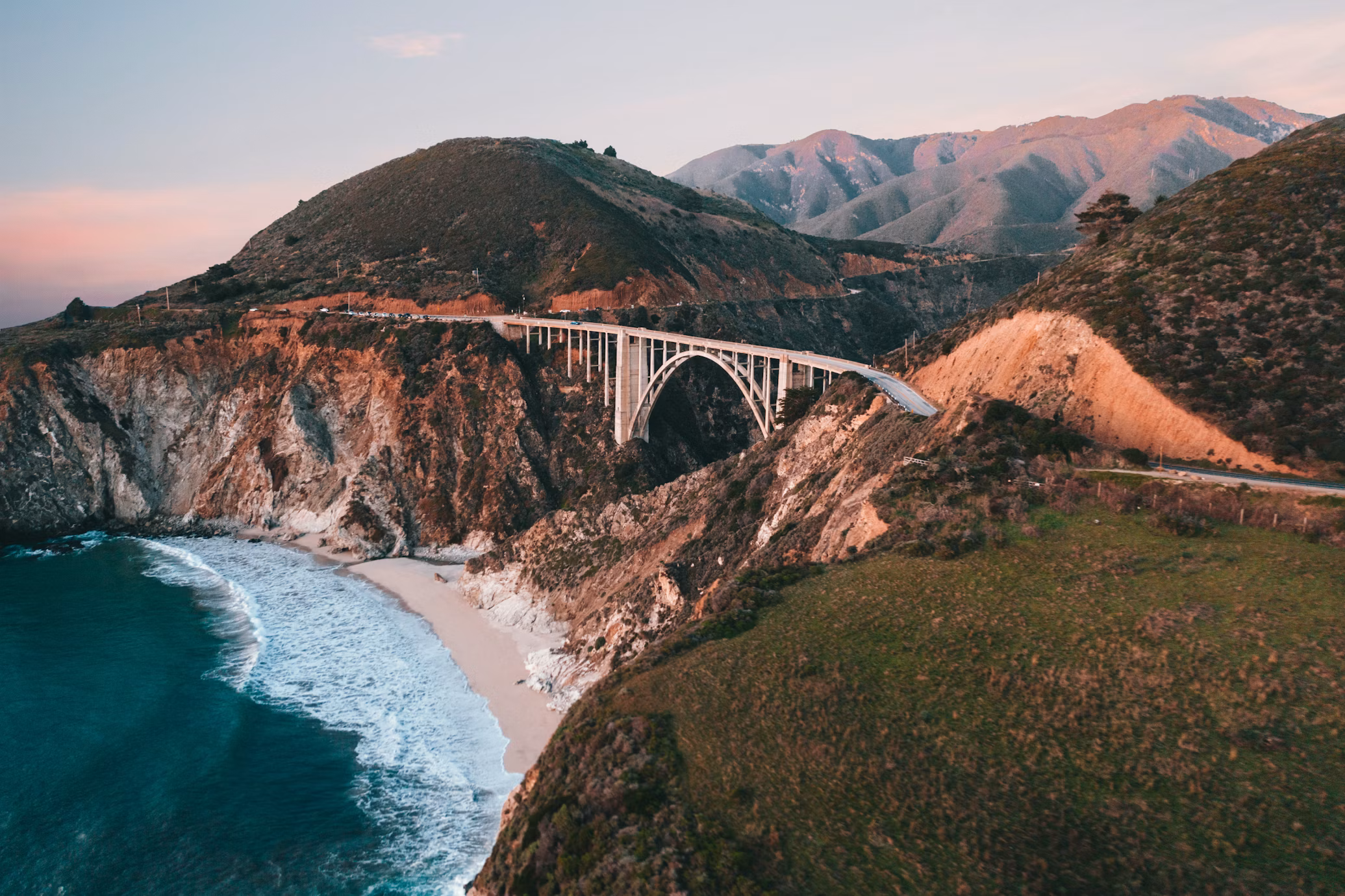
Bixby Creek Bridge
29 miles south of Monterey on Highway 1 — the most photographed bridge in California. The reinforced concrete arch bridge spans a 260-foot deep canyon with the Pacific stretching south to the horizon on both sides.
The standard view is from the north pullout — the bridge in the foreground, the coast curving away to the south, the mountains rising behind. At golden hour the concrete arch turns gold against the blue Pacific and the green hills. Go at sunset.
There is no safe place for large vehicles to stop at the north pullout — it's designed for passenger cars. Smaller RVs can fit with care. Larger rigs should stop at the Rocky Creek Bridge 4 miles north — similar architecture, less traffic, better access.
Hurricane Point
The exposed headland between Bixby Bridge and Big Sur Valley — one of the windiest spots on the California coast and one of the best whale watching locations on the entire drive. Gray whales pass close to shore during the December-April migration. California condors are occasionally seen riding thermals above the cliffs.
Big Sur Valley
The Big Sur River meets the Pacific in a valley surrounded by mountains — the heart of the Big Sur community with the handful of restaurants, lodges, and services that exist on this stretch of coast.
Pfeiffer Big Sur State Park
Old-growth redwoods in the Big Sur River canyon a mile from the Pacific. The park has the best campground infrastructure on the Big Sur coast and the best combination of redwood forest and coastal access anywhere on the drive.
Pfeiffer Falls and Valley View Trail Difficulty: Moderate Distance: 1.6 miles round trip to falls, 2.7 miles round trip to Valley View
The Pfeiffer Falls trail climbs through a redwood canyon to a 60-foot waterfall. The Valley View extension continues to an overlook above the tree canopy with views of the Pacific. Do both.
Big Sur Bakery and Restaurant — the best restaurant in Big Sur. A wood-fired bakery and restaurant using local ingredients. Breakfast and lunch are excellent — dinner requires reservations well in advance. The morning pastries are worth stopping for even if you don't stay for a full meal.
Camping at Pfeiffer Big Sur:
Pfeiffer Big Sur State Park Campground — the main Big Sur campground with full hookups on some sites. The most popular campground on the coast — book months in advance on Reserve America.
Book on Reserve America → [affiliate link]
Pfeiffer Beach
A purple-tinged sand beach in a cove below the road — the sand contains manganese garnet that gives it a distinctive purple tint in wet areas. The keyhole rock arch at the north end of the beach frames the surf perfectly.
Access via Sycamore Canyon Road — a narrow 2-mile dirt road that descends steeply to the beach. Not accessible for RVs — park at Pfeiffer Big Sur State Park and drive down in a tow vehicle or taxi.
Andrew Molera State Park
The largest state park on the Big Sur coast — 4,800 acres of coastal bluffs, river canyon, and beach. The Bluffs Trail runs along the cliff top above the Pacific with the best continuous cliff-edge views on the drive. The beach at the Big Sur River mouth is one of the most beautiful in California — wide, usually uncrowded, and backed by the Santa Lucia Mountains.
Bluffs Trail: 4 miles round trip, moderate
McWay Falls
Julia Pfeiffer Burns State Park — one of the only coastal waterfalls in California that falls directly onto a beach. McWay Falls drops 80 feet from a cliff into a turquoise cove surrounded by granite boulders and beach sand.
The overlook trail is 0.5 miles round trip from the parking area through a tunnel under the highway. The view of the falls from the overlook is one of the most photographed in California — best in morning light when the sun hits the cove directly.
You cannot access the beach below the falls — the cove is protected and there is no trail down. The overlook is the view.
Jade Cove
A cove south of Julia Pfeiffer Burns where nephrite jade — California's state gemstone — washes up on the beach. Jade collecting is permitted below the high tide line. The scramble down to the beach is steep and unmarked — use caution.
Esalen Institute
A famous human potential institute and retreat center at the base of the cliffs with hot spring baths directly above the ocean. Public access to the baths is available from midnight to 3am on a first-come basis — an unusual and genuinely extraordinary experience of soaking in hot springs above the Pacific in the middle of the night.
San Simeon — Hearst Castle
65 miles south of Big Sur on Highway 1. William Randolph Hearst's private estate on a hilltop above the Pacific — a 165-room main house with three swimming pools, a private zoo, and art collections assembled from across Europe over decades of acquisition.
Guided tours are required and there are multiple tour options ranging from the main estate to the cottages to the evening tours. Book at hearstcastle.org in advance — tours sell out on summer weekends.
The Neptune Pool alone — an outdoor pool surrounded by ancient Roman temple façade on a hilltop with Pacific views — justifies the visit.
Elephant Seals at Piedras Blancas
Just north of Hearst Castle — a rookery of northern elephant seals that haul out on the beach year-round with peak activity during pupping season in January and February. The beach is covered with thousands of seals during peak season — bulls fighting, mothers nursing pups, juveniles piling on each other. One of the great wildlife spectacles on the California coast. Free to view from a boardwalk above the beach.
Morro Bay — The southern anchor
Morro Bay is a small fishing town built around a harbor dominated by Morro Rock — a 576-foot volcanic plug rising from the bay. Sea otters float in the harbor kelp, harbor seals haul out on the rocks, and the estuary behind the town is one of the best birding sites on the central California coast.
Morro Rock — a state historic landmark and falcon nesting site. The rock is closed to climbing but accessible at the base by a short walk from the parking area. The view of the harbor from the base is excellent.
Morro Bay State Park — camping on the bay with full hookups and direct water views. One of the best state park campgrounds on the central coast.
Book on Reserve America → [affiliate link]
The Embarcadero — a waterfront street with seafood restaurants and fish markets serving what came off the boats that morning. The clam chowder and fresh fish tacos at multiple restaurants are consistently excellent.
Practical notes for Big Sur
Cell service is nonexistent through most of Big Sur. Download offline maps before leaving Monterey. There is no cell service from roughly Carmel to Morro Bay on Highway 1. Starlink handles the coast well.
Landslides close Highway 1 periodically. The road has a history of closures from landslides and erosion — most recently a major closure in 2017 that lasted over a year. Check current road status at dot.ca.gov before your trip. When Highway 1 is closed, there is no alternate coastal route — the inland detour adds 2+ hours.
Fog. The Big Sur coast is fogged in frequently — particularly in June and July. The fog can be thick enough to reduce visibility to a few car lengths on the cliff sections. Never drive Highway 1 in heavy fog. If fog closes in while you're driving, pull over at the next safe pullout and wait.
Campground reservations. Pfeiffer Big Sur and Kirk Creek fill up months in advance for summer weekends. Reserve America opens reservations six months ahead — book the day they open.
Where to camp
Pfeiffer Big Sur State Park — full hookups, in the redwoods, best infrastructure on the coast. Book on Reserve America → [affiliate link]
Kirk Creek Campground — Forest Service, on the bluff above the ocean, no hookups, one of the most dramatic campground settings in California. Book on Recreation.gov → [affiliate link]
Plaskett Creek Campground — Forest Service, slightly south of Kirk Creek, similar ocean bluff setting. Book on Recreation.gov → [affiliate link]
Morro Bay State Park — full hookups, bay views, southern end of the drive. Book on Reserve America → [affiliate link]
Gear for Big Sur
Part of the Central California RV Road Trip
The Ultimate Central California RV Road Trip →
Lorem ipsum dolor sit amet consectetur adipiscing eli mattis sit phasellus mollis sit aliquam sit nullam.