Subscribe to our newsletter today
Lorem ipsum dolor sit amet consectetur adipiscing eli mattis sit phasellus mollis sit aliquam sit nullam.
Central California RV road trip — San Francisco, Yosemite, Sequoia & Kings Canyon, Big Sur, Highway 1, Monterey, and Lake Tahoe with campground recommendations, RV size restrictions, and practical planning tips.
Venenatis sollicitudin posuere elit consequat et enim. Neque tortor amet dictum tempor. Leo facilisis aliquet viverra scelerisque eleifend viverra est. At massa erat vel amet enim laoreet dictum pellentesque. Urna cursus quam pulvinar tellus. Duis fermentum nibh volutpat morbi. Et ac sed ultricies ut nunc sodales lectus.
Et urna ac et maecenas fusce amet. Nibh nec commodo massa sed. Tincidunt porttitor in pharetra egestas sit neque ac lacus. Amet a nunc et cum. Odio at volutpat volutpat in leo eget ipsum diam elementum. Erat magna arcu orci lorem senectus orci fringilla. Tincidunt metus nisl vitae maecenas pretium aliquet.
Quis faucibus massa sit egestas. Sit fermentum est ac pulvinar et sagittis sed sit ut. Quis faucibus aenean nibh vestibulum enim mi sit. Sollicitudin ultrices ultrices in ipsum urna fringilla massa leo. Sapien ultricies vitae rhoncus molestie purus. Urna urna dolor euismod porttitor et. Magna adipiscing dictum et adipiscing mollis feugiat.

Quis faucibus massa sit egestas. Sit fermentum est ac pulvinar et sagittis sed sit ut. Quis faucibus aenean nibh vestibulum enim mi sit. Sollicitudin ultrices ultrices in ipsum urna fringilla massa leo. Sapien ultricies vitae rhoncus molestie purus. Urna urna dolor euismod porttitor et. Magna adipiscing dictum et adipiscing mollis feugiat.
Cursus curabitur euismod vel fermentum sapien non dolor odio vel. Tortor lectus mauris in praesent a tincidunt nam. In aenean odio aliquet pretium viverra elit quis magna. Eget ut risus posuere velit purus nisi nec sollicitudin. Tellus enim interdum neque sit vestibulum lacus. Nam pulvinar a lectus justo aliquet integer amet.
“Sed id mi eget urna facilisis pharetra nunc viverra est at magna maximus consectetur sed nec maximus augue aliquam commodo sem eu.”
Cursus curabitur euismod vel fermentum sapien non dolor odio vel. Tortor lectus mauris in praesent a tincidunt nam. In aenean odio aliquet pretium viverra elit quis magna. Eget ut risus posuere velit purus nisi nec sollicitudin. Tellus enim interdum.
Sed non quis tellus velit orci. Quam sed mauris elementum tempor viverra. Luctus semper risus ipsum id diam praesent. Pretium eget mauris ultrices curabitur sed sem amet. Erat nulla habitant in mattis massa mi adipiscing ullamcorper condimentum. Erat quisque integer tincidunt ac amet tempor vulputate tristique.
Sed non quis tellus velit orci. Quam sed mauris elementum tempor viverra. Luctus semper risus ipsum id diam praesent. Pretium eget mauris ultrices curabitur sed sem amet. Erat nulla habitant in mattis massa mi adipiscing ullamcorper condimentum. Erat quisque integer tincidunt ac amet tempor vulputate tristique.
Sed non quis tellus velit orci. Quam sed mauris elementum tempor viverra. Luctus semper risus ipsum id diam praesent. Pretium eget mauris ultrices curabitur sed sem amet. Erat nulla habitant in mattis massa mi adipiscing ullamcorper condimentum.
Central California contains more iconic landscapes per square mile than almost anywhere in the country. A world-class city on a bay. The most visited national park in America. The largest living things on earth. 90 miles of the most dramatic coastal highway in the world. And a high alpine lake at 6,200 feet that turns Caribbean blue in summer.
Most visitors experience one or two of these on a single trip. The RVer who takes two weeks and connects them all gets something different — a complete picture of what makes California extraordinary.
Here's how to do it right.
The route
San Francisco → Yosemite National Park → Sequoia & Kings Canyon National Parks → Big Sur & Highway 1 → Monterey → Santa Cruz → San Francisco
Total driving distance: approximately 700 miles as a loop. Recommended time: 12–14 days minimum. Two weeks lets you breathe. Three weeks lets you do it justice.
Add Lake Tahoe as a northern extension from San Francisco — a 3-hour drive northeast that adds two days and one of the great alpine lake experiences in the country.
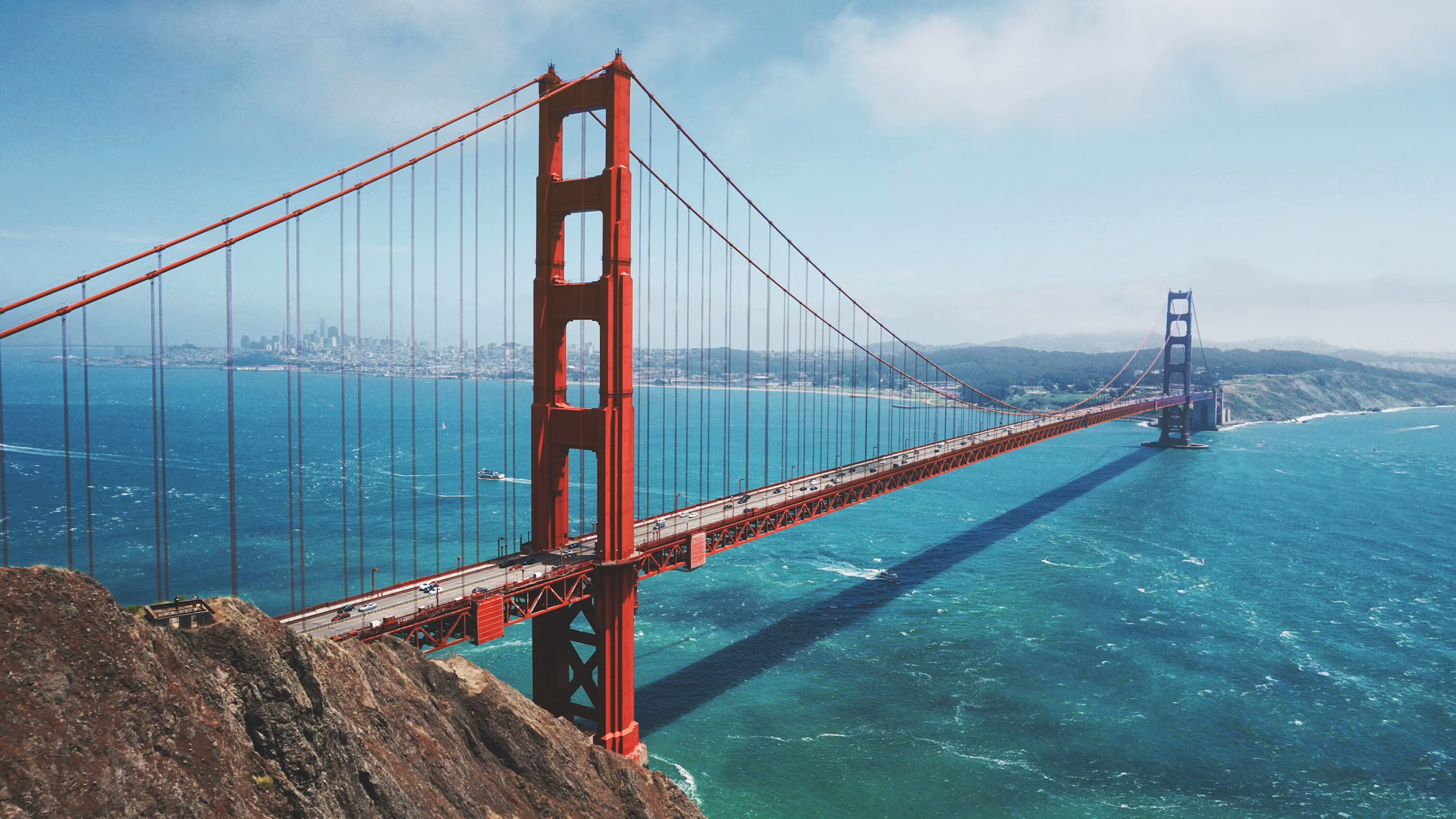
San Francisco — The gateway
San Francisco is not an easy city for RVs — narrow streets, steep hills, aggressive parking enforcement, and almost no overnight RV parking in the city itself. Base camp outside the city and use public transit or rideshare to explore.
The best RV bases near San Francisco:
Pacifica/Half Moon Bay — 20 miles south on Highway 1. The San Francisco North/Petaluma KOA and the Half Moon Bay State Beach campground put you close enough to BART or Caltrain for city access.
Book on Campspot → [affiliate link]
Marin County — north of the Golden Gate Bridge. Olema Ranch Campground near Point Reyes and the Pantoll Campground in Mount Tamalpais State Park are excellent options.
Book on Reserve America → [affiliate link]
What's worth the trip into the city:
Golden Gate Bridge — walk or bike across from the Marin side. The views of the bay, the city, and the Pacific from the bridge deck are extraordinary. The bike path is separated from traffic and the ride from Sausalito across the bridge and down to the Ferry Building is one of the great urban cycling experiences in the country.
Ferry Building Marketplace — the best food market in San Francisco on the Embarcadero waterfront. Tuesday and Saturday farmers markets. Acme Bread, Cowgirl Creamery, Blue Bottle Coffee, and a dozen excellent restaurants all under one roof. Plan two hours minimum.
Muir Woods National Monument — 12 miles north of the Golden Gate Bridge in Marin County. Old-growth coast redwoods in a creek canyon — the best redwood experience accessible from San Francisco. Shuttle is required from the Muir Woods parking area — private vehicles are restricted. The shuttle from Sausalito makes it easy. Go on a weekday if possible.
Point Reyes National Seashore — 30 miles north of the Golden Gate on Highway 1. A dramatic peninsula extending into the Pacific with lighthouse, elk herds, dramatic cliffs, and one of the best coastal hiking areas in Northern California. The Point Reyes Lighthouse at the tip of the peninsula has the best views of any lighthouse in California. RV-accessible parking at the main trailheads.
Napa and Sonoma — an hour north of San Francisco. Wine country deserves its own article and its own visit — covered separately in the Wine Country RV guide coming soon.
Yosemite National Park
Yosemite Valley is the most visited destination in the national park system and the most difficult RV destination to manage logistics around. The valley floor — 7 miles long and one mile wide, surrounded by 3,000-foot granite walls — receives four million visitors per year and the infrastructure strains visibly under the load.
None of that diminishes the experience of seeing El Capitan for the first time. Or Half Dome at sunrise. Or Yosemite Falls in spring when the snowmelt sends full volume water over the cliff.
Yosemite rewards the visitor who plans carefully and arrives prepared.
Getting there with an RV
There are four entrances to Yosemite:
Big Oak Flat entrance (Highway 120 west) — the most common approach from San Francisco and the Bay Area. The road is well-maintained and handles most RVs.
Arch Rock entrance (Highway 140) — the most scenic approach through the Merced River canyon. Recommended for most RVers — the road follows the river through a beautiful gorge and the approach to the valley is dramatic.
South entrance (Highway 41) — from Fresno and Southern California. Passes through the Wawona area and the Mariposa Grove.
Tioga Pass entrance (Highway 120 east) — from Lee Vining and Highway 395. Open late May through early November. The highest paved road in California crossing the Sierra at 9,945 feet. RVs over 35 feet are not recommended on Tioga Road — the road is paved but has tight sections and steep grades. Smaller rigs can handle it with care.
The Yosemite Valley reservation system
A timed entry reservation is required to enter Yosemite Valley from late March through early October. Reservations are released on Recreation.gov one week in advance on a rolling basis and sell out within minutes. Set a daily reminder and check at 8am Pacific time — that's when new availability appears.
The campground reservation system
Yosemite's campgrounds are among the most competitive reservations in the national park system. Upper Pines, Lower Pines, and North Pines in the valley book up five months in advance on Recreation.gov the day reservations open. Set a reminder for exactly five months before your desired date and book at 7am Pacific.
Valley campgrounds:
Upper Pines Campground — the largest valley campground with the best RV access. Some sites accommodate rigs up to 35 feet. Electric hookups are not available in Yosemite Valley campgrounds — all valley camping is dry camping.
Book on Recreation.gov → [affiliate link]
Outside the valley:
Hodgdon Meadow Campground — near the Big Oak Flat entrance. Some hookups available. First reservable campground near the valley — good option when valley sites are full.
Book on Recreation.gov → [affiliate link]
Wawona Campground — in the southern part of the park near the Mariposa Grove. Some hookups. Good base for sequoia grove access.
Book on Recreation.gov → [affiliate link]
Crane Flat Campground — a good mid-park option between the valley and Tuolumne Meadows.
Book on Recreation.gov → [affiliate link]
What not to miss:
Yosemite Valley floor
The valley floor contains the most concentrated collection of iconic landscapes in the national park system. El Capitan — a 3,000-foot vertical granite wall — towers over the western valley. Half Dome closes the eastern end. Yosemite Falls drops 2,425 feet in two tiers on the north wall. Bridalveil Fall catches the afternoon light on the south wall. Mirror Lake reflects Half Dome on calm mornings.
The Valley Loop Trail — 13 miles of mostly flat trail connecting all the major valley viewpoints — is the best way to experience the valley floor without a car. Rent bikes from Yosemite Valley Lodge or Curry Village and ride sections at dawn before the shuttle crowds arrive.
Tunnel View
The overlook at the east end of the Wawona Tunnel frames the entire Yosemite Valley in a single view — El Capitan on the left, Half Dome in the center, Bridalveil Fall on the right. It's the most reproduced view in Yosemite and it's reproduced because it's extraordinary. Arrive before sunrise and watch the valley fill with light.
Glacier Point
A viewpoint at 7,214 feet on the south rim of the valley with views straight down 3,200 feet to the valley floor and across to Half Dome at eye level. One of the great overlook views in the national park system. The Glacier Point Road is closed in winter — open typically late May through early November. RVs over 35 feet are not permitted on Glacier Point Road.
Half Dome
The most iconic formation in Yosemite — a granite dome with one vertical face sheared off by glaciation. The cables route to the summit is one of the most famous hikes in the country — 17 miles round trip with 4,800 feet of elevation gain and metal cables on the final 400 feet of steep granite.
A permit is required for the cables section — released by lottery in the spring for the following season and as daily walk-up permits. Extremely competitive. Apply in the spring lottery if the summit is your goal.
Vernal and Nevada Falls — The Mist Trail Difficulty: Strenuous Distance: 5.4 miles round trip to Nevada Fall
The best hike in Yosemite. The Mist Trail climbs stone steps beside Vernal Fall — getting soaked in the spray on the way up — to the top of the fall, then continues to Nevada Fall above. The views from the top of Nevada Fall looking back down into the valley are extraordinary. Do this hike.
Yosemite Falls Trail Difficulty: Strenuous Distance: 7.2 miles round trip
Climbs from the valley floor to the top of the upper fall with views down the valley from the rim. Best in spring when the falls are at full volume. The upper fall viewpoint is one of the great views in the park.
Mariposa Grove
The largest sequoia grove in Yosemite — 500 mature giant sequoias in the southern part of the park accessible via shuttle from Wawona. The Grizzly Giant at 2,700 years old is the oldest sequoia in the park. The fallen Tunnel Tree — once driven through by cars — lies on the forest floor. Walk the 2-mile round trip to the Grizzly Giant and Bachelor and Three Graces for the essential grove experience.
Tuolumne Meadows
At 8,600 feet in the high Sierra — the largest subalpine meadow in the Sierra Nevada, surrounded by granite domes and peaks. The scenery is completely different from the valley — open, airy, and expansive rather than enclosed and dramatic. Excellent hiking to Lembert Dome, Cathedral Lakes, and the Young Lakes. The Tuolumne Meadows Lodge and campground make it an excellent base for high Sierra exploration.
Book on Recreation.gov → [affiliate link]
Full guide: Best Things To Do at Yosemite National Park with an RV → ← coming soon
Sequoia & Kings Canyon National Parks
Sequoia and Kings Canyon are administered jointly and experienced together — two parks with completely different characters sharing a boundary in the southern Sierra Nevada.
Sequoia protects the largest living things on earth by volume — giant sequoias that grow only on the western slopes of the Sierra Nevada between 4,500 and 7,000 feet. Kings Canyon protects one of the deepest canyons in North America — deeper than the Grand Canyon at its deepest point — carved by the Kings River through the heart of the Sierra.
Both are significantly less visited than Yosemite despite containing landscapes that are arguably more extraordinary.
Getting there with an RV
The main entrance to Sequoia is Highway 198 from Visalia. The Generals Highway connecting the two parks is paved but has tight switchbacks — RVs over 22 feet are not recommended on the section between the Ash Mountain entrance and Giant Forest. Larger rigs enter from the Big Stump entrance on Highway 180 from Fresno which avoids the restricted section.
General Sherman Tree
The largest living thing on earth by volume — a giant sequoia 274 feet tall, 36 feet in diameter at the base, and 2,200 years old. A 2-mile round trip trail through the Giant Forest connects the General Sherman to several other massive sequoias. Standing at the base of a tree this size resets your sense of scale in a way photographs cannot convey.
Congress Trail
A 2-mile loop through the densest concentration of giant sequoias in the world — the President, the Chief Sequoyah, the General Lee, and dozens of other named trees. The forest floor is open and park-like under the giant trees. One of the most extraordinary short walks in the national park system.
Moro Rock
A granite dome rising from the Giant Forest with a trail of 350 steps climbing to the summit — panoramic views of the Great Western Divide and the surrounding Sierra from the top. 0.5 miles round trip. One of the best accessible viewpoints in the park.
Crystal Cave
A marble cave inside Sequoia accessible by guided tour only — stalactites, stalagmites, and unusual crystal formations in a cave system carved by an underground river. Tours run from mid-May through late November. Book at recreation.gov in advance.
Kings Canyon Scenic Byway
Highway 180 descends from the Grant Grove area into Kings Canyon — dropping 2,600 feet into one of the deepest river canyons in North America. The canyon walls rise 8,000 feet above the canyon floor in places. The road ends at Road's End — a trailhead for the backcountry with excellent day hiking in the canyon.
Grant Grove
The General Grant Tree — the second largest tree in the world and the only living thing designated a National Shrine. The short loop trail through Grant Grove visits the General Grant, the Fallen Monarch, and the Gamlin Cabin. The grove feels different from Giant Forest — more intimate, with the trees growing closer together.
Camping at Sequoia & Kings Canyon:
Lodgepole Campground — the main campground in Sequoia near the Giant Forest. Some hookups. Books up well in advance.
Book on Recreation.gov → [affiliate link]
Sunset Campground — in Grant Grove at the Kings Canyon entrance. Electric hookups. Good base for Grant Grove and the Kings Canyon drive.
Book on Recreation.gov → [affiliate link]
Full guide: Best Things To Do at Sequoia & Kings Canyon with an RV → ← coming soon
Big Sur & Highway 1
Highway 1 along the Big Sur coast is one of the most dramatic drives in the world — 90 miles of two-lane road carved into the cliffs above the Pacific, crossing bridges over canyon mouths, passing through redwood groves, and delivering views of the ocean from heights that make you feel suspended between the mountains and the sea.
RV considerations on Highway 1
Highway 1 through Big Sur is not recommended for RVs over 40 feet or for vehicles towing trailers over 35 feet. The road has tight curves, narrow lanes, and pullouts that are too small for large rigs. Most RVers drive it in a smaller tow vehicle and base camp in Monterey or Morro Bay at either end.
If you want to drive Highway 1 in your RV — rigs under 35 feet can handle it with care and patience. Drive slowly, use pullouts generously, and don't attempt it after dark.
Key stops on the Big Sur coast:
Bixby Creek Bridge — the most photographed bridge in California. The arch bridge spans a 260-foot canyon above the Pacific — the classic Big Sur composition with the bridge in the foreground and the coast stretching to the horizon. A pullout on the north side of the bridge provides the standard view. Go at golden hour.
McWay Falls — an 80-foot waterfall that drops directly onto a beach in a cove at Julia Pfeiffer Burns State Park. One of the only coastal waterfalls in California that falls onto a beach — the combination of the turquoise cove, the waterfall, and the surrounding cliffs is extraordinary. Short walk from the parking area.
Pfeiffer Big Sur State Park — old-growth redwoods in a river canyon a mile from the Pacific. The Pfeiffer Falls trail is excellent and the park has the best campground infrastructure on the Big Sur coast. Full hookups on some sites.
Book on Reserve America → [affiliate link]
Andrew Molera State Park — the largest state park on the Big Sur coast with beach access, coastal hiking, and the best bluff trail views on the entire route. The beach at the mouth of the Big Sur River is one of the most beautiful in California.
Point Sur Lightstation — a historic lighthouse on a volcanic rock promontory accessible by guided tour only. The tours are excellent and the views from the rock are extraordinary.
Hearst Castle — 65 miles south of Big Sur near San Simeon. William Randolph Hearst's private estate on a hilltop above the Pacific — a 165-room house with three swimming pools, a private zoo, and art collections assembled from across Europe. Guided tours are required — book at hearstcastle.org in advance.
Elephant seals at Piedras Blancas — just north of Hearst Castle, a rookery of northern elephant seals that haul out on the beach year-round. In January and February the beach is covered with thousands of seals during pupping season — one of the great wildlife spectacles on the California coast. Free to view from a boardwalk above the beach.
Camping on the Big Sur coast:
Pfeiffer Big Sur State Park Campground — the main campground in Big Sur with full hookups on some sites. Books up months in advance.
Book on Reserve America → [affiliate link]
Kirk Creek Campground — a Forest Service campground on the bluff above the ocean with direct Pacific views from the sites. No hookups. One of the most dramatic campground settings in California.
Book on Recreation.gov → [affiliate link]
Full guide: Big Sur & Highway 1 RV Road Trip → ← coming soon
Monterey
Monterey is the best gateway city for Big Sur — a former sardine fishing port with excellent seafood, a world-class aquarium, and a historic downtown that rewards walking.
Monterey Bay Aquarium — consistently ranked among the best aquariums in the world. The kelp forest exhibit, the jellyfish gallery, and the open sea tank with bluefin tuna and ocean sunfish are extraordinary. Plan a full day. Book tickets in advance — the aquarium sells out on summer weekends.
Cannery Row — the historic sardine cannery district immortalized by John Steinbeck. The canneries closed in the 1950s when the sardine population collapsed and the area is now restaurants and shops — more tourist than literary, but the waterfront setting is excellent.
17-Mile Drive — a private toll road through the Del Monte Forest on the Monterey Peninsula passing Pebble Beach Golf Links, the Lone Cypress, and some of the best ocean views on the central coast. The toll is worth it. Most RVs are permitted on the drive — check current vehicle restrictions at the gate.
Carmel-by-the-Sea — a small artist community south of Monterey with excellent galleries, restaurants, and a white sand beach backed by Monterey cypress. Worth an afternoon.
Camping near Monterey:
Monterey Pines RV Resort — full hookups near Monterey. Good base for the aquarium and Big Sur access.
Book on Campspot → [affiliate link]
Lake Tahoe
Lake Tahoe sits at 6,225 feet on the California-Nevada border — a glacially carved lake 22 miles long, 12 miles wide, and 1,645 feet deep. The water clarity is extraordinary — the Secchi depth exceeds 70 feet and the deep water is an intense blue that shifts to turquoise in the shallows. The Sierra Nevada surrounds it on three sides.
In summer it's a water sports and hiking destination. In winter it's one of the premier ski destinations in the country with over a dozen resorts around the lake.
Getting there with an RV
Highway 50 from Sacramento and Highway 89 from Reno are the main approaches. The roads around the lake are paved and generally handle most RVs — some sections of Highway 89 on the west shore have tight curves. The full lake loop is 72 miles on Highways 28 and 89.
South Lake Tahoe
The largest town on the lake — the Nevada border runs through the middle with California casinos on one side and Nevada casinos on the other. The south shore has the best beach access and the most developed tourist infrastructure.
Emerald Bay State Park — the most photographed spot on Lake Tahoe. A narrow bay with water so intensely turquoise it looks tropical — Fannette Island, the only island in Lake Tahoe, sits in the middle of the bay. Vikingsholm, a Scandinavian-style castle built in 1929, sits at the bay's edge accessible by a 1-mile steep trail from the overlook parking area.
The overlook above the bay is free and accessible from Highway 89. The trail to Vikingsholm requires a day use fee.
Eagle Falls — a short trail from the Emerald Bay parking area to a waterfall above the bay. 0.5 miles round trip. The falls and the bay view together make this one of the best short walks on the lake.
D.L. Bliss State Park — one of the best beaches on Lake Tahoe with crystal clear water over white granite boulders. The Rubicon Trail runs 4.5 miles along the west shore from Bliss to Vikingsholm — one of the best lake-level hiking trails in Tahoe.
North Lake Tahoe
The north shore is less developed and more scenic than the south — smaller towns, better beaches, and direct access to the ski resorts at Squaw Valley and Northstar.
Sand Harbor — the best beach on the lake. White granite boulders, clear turquoise water, and views across the lake to the Sierra. Nevada State Park day use fee. Gets extremely crowded on summer weekends — arrive before 9am or plan to wait for parking.
Incline Village — a small Nevada lakeside community with excellent dining and the best access to the East Shore Trail — a 6-mile trail along undeveloped lakeshore with the best views of the Sierra across the water.
Lake Tahoe hiking:
Mount Tallac Difficulty: Strenuous Distance: 9.4 miles round trip Elevation gain: 3,294 feet
The best summit hike around Lake Tahoe — climbs from the south shore to 9,735 feet with views of the entire lake, Desolation Wilderness, and the surrounding Sierra. The snow cross on the north face visible from the south shore is a local landmark. Start early — the summit is exposed and afternoon thunderstorms are common in summer.
Desolation Wilderness
The most visited wilderness area in the United States per square mile — a granite wilderness of lakes, peaks, and glacially polished rock accessible from multiple trailheads around the south and west shores. Day hiking permits are required from June through September — self-issue at the trailhead. Overnight permits book up well in advance.
Camping at Lake Tahoe:
D.L. Bliss State Park Campground — one of the best campground settings in California. Sites in a forest above the lake with beach access. Books up months in advance.
Book on Reserve America → [affiliate link]
Fallen Leaf Lake Campground — a Forest Service campground on a smaller lake adjacent to Tahoe near South Lake Tahoe. Full hookups on some sites.
Book on Recreation.gov → [affiliate link]
Tahoe Valley Campground — a full-hookup private campground in South Lake Tahoe. The best hookup option near the lake.
Book on Campspot → [affiliate link]
Full guide: Lake Tahoe & the Sierra Nevada RV Guide →
Practical notes for Central California
Yosemite requires advance planning above everything else. The timed entry reservation, the campground lottery, and the Half Dome permit all require months of advance booking. If Yosemite is on your itinerary, start the reservation process six months before your trip.
The Generals Highway RV restriction is real. RVs over 22 feet cannot drive the restricted section from Ash Mountain to Giant Forest. Plan your Sequoia approach via Highway 180 from the north if you're in a larger rig.
Highway 1 through Big Sur demands respect. Tight curves, no guardrails in many sections, and fog that can reduce visibility to near zero. Drive slowly, use pullouts, and don't attempt it in a hurry or after dark.
Summer crowds at Yosemite are extreme. The valley parking fills by 9am on summer weekends even with the timed entry system. Use the valley shuttle once you're parked. Consider shoulder season — May or September/October — for a significantly better experience.
Lake Tahoe summer weekends are also crowded. The lake draws day trippers from Sacramento and the Bay Area every weekend. Arrive Friday evening or Monday morning. The campgrounds near the lake are worth any crowd inconvenience — the water is extraordinary.
Wildfire smoke. The Sierra Nevada has significant fire activity in late summer. August and September can bring smoke that reduces visibility dramatically. Have flexible itinerary options and check airnow.gov daily.
Gear for Central California
Explore each destination in depth
Part of the Ultimate California RV Road Trip
Central California is the heart of the ultimate California loop — connecting north to the Redwoods and south to the wine country and Southern California.
The Ultimate California RV Road Trip → ← coming soon
Bottom Line
Start in San Francisco. Cross the Golden Gate and walk Muir Woods on the first morning. Drive to Yosemite and give it three nights minimum — hike the Mist Trail, watch the sunrise at Tunnel View, ride bikes on the valley floor at dawn. Head south to Sequoia and stand at the base of the General Sherman. Drive Big Sur in your tow vehicle and stop at every pullout on Highway 1. Eat in Monterey. Add Lake Tahoe if you have two extra days — the water alone is worth it.
Central California is the trip that defines California for most visitors. The crowds at Yosemite are real and manageable with the right planning. The rewards are extraordinary and genuinely unlike anything else in the country.
Plan early. Book everything. Show up.
Lorem ipsum dolor sit amet consectetur adipiscing eli mattis sit phasellus mollis sit aliquam sit nullam.