Subscribe to our newsletter today
Lorem ipsum dolor sit amet consectetur adipiscing eli mattis sit phasellus mollis sit aliquam sit nullam.
Death Valley National Park RV guide — Badwater Basin, Zabriskie Point, sand dunes, Dante's View, driving distances from Las Vegas and Los Angeles, the Whitney to Badwater connection, and campground recommendations.
Venenatis sollicitudin posuere elit consequat et enim. Neque tortor amet dictum tempor. Leo facilisis aliquet viverra scelerisque eleifend viverra est. At massa erat vel amet enim laoreet dictum pellentesque. Urna cursus quam pulvinar tellus. Duis fermentum nibh volutpat morbi. Et ac sed ultricies ut nunc sodales lectus.
Et urna ac et maecenas fusce amet. Nibh nec commodo massa sed. Tincidunt porttitor in pharetra egestas sit neque ac lacus. Amet a nunc et cum. Odio at volutpat volutpat in leo eget ipsum diam elementum. Erat magna arcu orci lorem senectus orci fringilla. Tincidunt metus nisl vitae maecenas pretium aliquet.
Quis faucibus massa sit egestas. Sit fermentum est ac pulvinar et sagittis sed sit ut. Quis faucibus aenean nibh vestibulum enim mi sit. Sollicitudin ultrices ultrices in ipsum urna fringilla massa leo. Sapien ultricies vitae rhoncus molestie purus. Urna urna dolor euismod porttitor et. Magna adipiscing dictum et adipiscing mollis feugiat.

Quis faucibus massa sit egestas. Sit fermentum est ac pulvinar et sagittis sed sit ut. Quis faucibus aenean nibh vestibulum enim mi sit. Sollicitudin ultrices ultrices in ipsum urna fringilla massa leo. Sapien ultricies vitae rhoncus molestie purus. Urna urna dolor euismod porttitor et. Magna adipiscing dictum et adipiscing mollis feugiat.
Cursus curabitur euismod vel fermentum sapien non dolor odio vel. Tortor lectus mauris in praesent a tincidunt nam. In aenean odio aliquet pretium viverra elit quis magna. Eget ut risus posuere velit purus nisi nec sollicitudin. Tellus enim interdum neque sit vestibulum lacus. Nam pulvinar a lectus justo aliquet integer amet.
“Sed id mi eget urna facilisis pharetra nunc viverra est at magna maximus consectetur sed nec maximus augue aliquam commodo sem eu.”
Cursus curabitur euismod vel fermentum sapien non dolor odio vel. Tortor lectus mauris in praesent a tincidunt nam. In aenean odio aliquet pretium viverra elit quis magna. Eget ut risus posuere velit purus nisi nec sollicitudin. Tellus enim interdum.
Sed non quis tellus velit orci. Quam sed mauris elementum tempor viverra. Luctus semper risus ipsum id diam praesent. Pretium eget mauris ultrices curabitur sed sem amet. Erat nulla habitant in mattis massa mi adipiscing ullamcorper condimentum. Erat quisque integer tincidunt ac amet tempor vulputate tristique.
Sed non quis tellus velit orci. Quam sed mauris elementum tempor viverra. Luctus semper risus ipsum id diam praesent. Pretium eget mauris ultrices curabitur sed sem amet. Erat nulla habitant in mattis massa mi adipiscing ullamcorper condimentum. Erat quisque integer tincidunt ac amet tempor vulputate tristique.
Sed non quis tellus velit orci. Quam sed mauris elementum tempor viverra. Luctus semper risus ipsum id diam praesent. Pretium eget mauris ultrices curabitur sed sem amet. Erat nulla habitant in mattis massa mi adipiscing ullamcorper condimentum.
Death Valley holds more records than any other national park in the country. The lowest point in North America. The hottest air temperature ever recorded on earth — 134°F on July 10, 1913. The driest place in North America. The largest national park in the lower 48 at 3.4 million acres.
And 84 miles from the lowest point in the Western Hemisphere to the highest peak in the contiguous United States.
That last one is the detail that stops people. You can stand at Badwater Basin at 282 feet below sea level in the morning and drive to the Whitney Portal trailhead — base camp for the 14,505-foot summit of Mount Whitney — in under two hours. No other place in the country puts those two extremes in the same afternoon.
Death Valley is not a place you visit because it's comfortable. You visit because it's extraordinary.
Getting there
From Las Vegas — 2 hours
The most common approach and the easiest. Take I-15 south to Highway 160 west through Pahrump, then Highway 190 into the park. Or take I-15 south to Highway 95 south to Highway 373 through Amargosa Valley into the park's eastern edge.
Las Vegas is the best gateway city for Death Valley — full RV services, major airport, and the 2-hour drive is entirely on well-maintained highway. Most RVers base camp in Las Vegas and day trip into the valley, or enter the park for 2–3 nights before continuing to Los Angeles or back north on Highway 395.
From Los Angeles — 3.5 to 4 hours
Two main approaches from LA:
Via I-15 north and Highway 127 north — the fastest route at 3.5 hours through Barstow and Baker. Highway 127 north from Baker is a straight desert highway through the Mojave before entering the park near Shoshone.
Via Highway 14 north to Highway 395 north to Highway 136 west — slightly longer at 4 hours but significantly more scenic. This route passes through the Mojave Desert, climbs into the Eastern Sierra, and approaches Death Valley from the north through Owens Valley. You pass through Lone Pine — the closest town to Mount Whitney — on this route, setting up the highest/lowest juxtaposition perfectly.
From Lone Pine and Highway 395 — 1.5 hours
Lone Pine sits at the base of Mount Whitney on Highway 395 — 85 miles from Badwater Basin. Highway 136 west from Lone Pine connects directly to Highway 190 into Death Valley. This is the route that puts the highest and lowest points in the same afternoon.
Drive from Whitney Portal in the morning — 8,365 feet above sea level with Whitney's 14,505-foot summit above you. Drive Highway 136 through the Owens Valley floor. Cross into Death Valley through the Panamint Range. Descend to Badwater Basin at 282 feet below sea level before noon.
The elevation change is 14,787 feet in 85 miles. Nothing else like it in the country.
When to go
This is the most important decision about Death Valley.
October through April — the window. Daytime temperatures are comfortable to warm — 60s to 80s in the heart of the season. Nights can be cold in December and January. The park is alive, accessible, and genuinely beautiful. The spring wildflower bloom in March and April — when winter rains are good — is one of the great natural spectacles in the Southwest.
May and September — shoulder season. Temperatures climb toward 100°F in May and are still high in September. Manageable in the early mornings and evenings. Crowds thin significantly.
June through August — Death Valley in summer is genuinely dangerous. Temperatures regularly exceed 120°F. The road surfaces reach 200°F. Tires fail. Engines overheat. People die every year from heat exposure. The park service strongly advises against summer hiking and activity outside of air-conditioned vehicles between 10am and sunset.
If you visit in summer: Stay in your air-conditioned RV or at Stovepipe Wells or Furnace Creek with air-conditioned facilities. Hike only before 8am or after sunset. Carry extraordinary amounts of water — a minimum of one gallon per person per hour of outdoor activity. Never, under any circumstances, hike to the salt flats or low elevation areas in midday summer.
The park is extraordinary year-round — but it will kill you if you underestimate it in summer.
The geography
Understanding Death Valley's geography makes the experience significantly richer.
The valley is a graben — a block of the earth's crust that dropped between two parallel fault lines while the surrounding mountains rose. The Panamint Range on the west side rises to 11,049 feet at Telescope Peak. The Black Mountains on the east side rise to 5,000 feet. The valley floor between them drops to 282 feet below sea level at Badwater Basin.
The combination of the below-sea-level elevation, the mountain walls trapping heat, and the extreme aridity creates the hottest surface temperatures on earth. The valley floor acts like a natural solar oven — heat radiates from the ground long after the sun sets.
Badwater Basin
The lowest point in North America at 282 feet below sea level — and the lowest point in the Western Hemisphere. A vast salt flat stretching across the valley floor, white and flat and seemingly infinite, with the Panamint Range rising behind it.
The salt flat is composed of sodium chloride, calcite, and gypite — deposited over thousands of years as the lake that once filled this basin evaporated. The surface is hard enough to walk on and the geometric salt crystal formations up close are extraordinary.
A sign on the cliff above the parking area marks sea level — 282 feet above where you're standing.
Walk out onto the salt flat. Go as far as you want — the flat extends for miles and the further you walk the better the silence and the scale. The crunch of salt crystals underfoot, the white expanse in every direction, the mountains rising on both sides, and the knowledge that you're standing at the lowest point in the Western Hemisphere is a genuinely unusual experience.
Go in the morning. The salt flat in direct afternoon sun in any season is extremely hot — the surface temperature can exceed 200°F in summer and is uncomfortable to stand on barefoot even in winter.
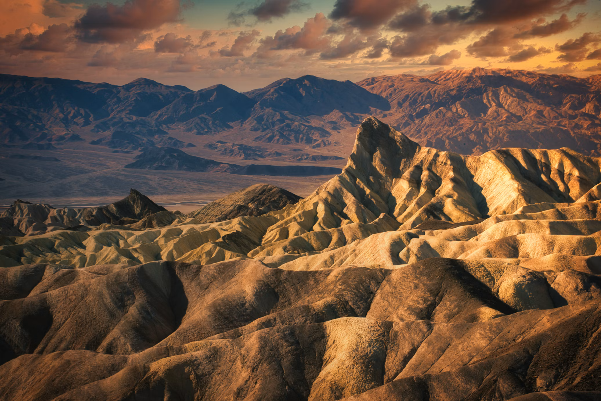
Zabriskie Point
An eroded badlands overlook east of Furnace Creek — golden and brown mudstone formations carved by ancient floods into a landscape that looks designed for a science fiction film. One of the most photographed spots in the park.
Sunrise at Zabriskie Point is the classic Death Valley experience. The golden light on the formations in the first 20 minutes after dawn is extraordinary — the colors shift from grey to orange to deep gold as the sun rises. Arrive before dawn and watch it happen.
The short walk from the parking area to the overlook takes five minutes. Extend it with the Golden Canyon Trail which descends into the badlands from a different trailhead for a 4-mile round trip through the formations up close.
Artist's Drive and Artist's Palette
A one-way 9-mile loop through the Black Mountains — paved, suitable for most passenger vehicles. The drive passes through dramatically colored volcanic deposits — green, purple, red, yellow, and pink hillsides created by oxidation of different minerals. Artist's Palette is the most colorful section, best in the late afternoon when the light hits directly.
RV note: Artist's Drive has vehicle length restrictions — vehicles over 25 feet are not permitted. Leave the rig at Furnace Creek and drive the loop in a tow vehicle.
Mesquite Flat Sand Dunes
The most accessible sand dunes in the park — visible from Highway 190 near Stovepipe Wells. The tallest dunes reach 100 feet and the field extends for several miles across the valley floor.
Walk out at sunrise or sunset when the dune shadows create dramatic photographic compositions. The dunes are easy to reach and require no trail — walk anywhere across the sand. At sunrise the dune crests are lined with the tracks of nocturnal animals — sidewinder rattlesnakes, kit foxes, and beetles — that crossed during the night.
Full moon nights on the dunes are one of the great Death Valley experiences. The sand reflects moonlight and the dunes are visible in silhouette against the star-filled sky. The temperature is comfortable on fall and winter full moon nights.
Dante's View
A 5,476-foot viewpoint above the Black Mountains on the east side of the valley — one of the great panoramic views in the national park system. The entire valley is visible from Badwater Basin below to the Panamint Range above, with the salt flats stretching south for miles.
On a clear day the white of Badwater Basin contrasts against the dark valley floor and the layered mountains on both sides in a composition that makes the valley's geological history visible all at once.
Getting there: A paved road climbs 13 miles from Highway 190. Vehicles over 25 feet not permitted on the road.Drive up in your tow vehicle.
Sunrise from Dante's View — the valley fills with color from above as the sun rises. The shadow of the Panamint Range retreats across the valley floor as the light builds. One of the best sunrise viewpoints in California.
Furnace Creek
The main hub of Death Valley — visitor center, Inn at Death Valley, Furnace Creek Resort, gas station, and the best date milkshake you'll ever drink.
Furnace Creek Visitor Center — the best starting point in the park. The rangers here are exceptional — knowledgeable, enthusiastic, and genuinely helpful with current road conditions and activity recommendations. The exhibits on Death Valley geology and natural history are excellent. Stop here first.
Inn at Death Valley — a historic luxury resort built in 1927 with a spring-fed pool at 85°F year-round. Non-guests can eat at the restaurant and walk the grounds. The date palm garden adjacent to the resort is one of the largest in the United States — the dates from these palms have been harvested since the 1920s.
Borax Museum — a free outdoor museum near the Furnace Creek Ranch documenting the borax mining history of Death Valley — the Twenty Mule Team wagons that hauled borax across the desert are one of the iconic images of the American West. The historic equipment in the outdoor collection is extensive.
The date milkshake — the Furnace Creek Ranch store sells date milkshakes made from dates grown in the adjacent palm garden. It's one of those specific regional food experiences that earns legendary status among repeat visitors. Get one.
Scotty's Castle
A 1920s Spanish-Moorish mansion in the remote Grapevine Canyon in the northern part of the park — built by Chicago millionaire Albert Johnson as a winter retreat and made famous by his friend Walter Scott who convinced visitors it was his own castle.
Currently closed for major flood damage repairs — a 2015 flash flood damaged the castle and the access road significantly. Check current status at nps.gov/deva before planning a visit. When open, the guided tours of the interior are excellent and the drive through the northern valley to reach it is worth doing regardless.
Salt Creek
A seasonal stream in the northern valley floor — one of the only places in Death Valley where water flows on the surface year-round. The Salt Creek pupfish — a species found nowhere else on earth, descended from fish that swam in the ancient lake that filled this basin 10,000 years ago — lives in this creek in isolation. The short boardwalk trail through the salt marsh is excellent for birdwatching in spring and for seeing the pupfish in the pools.
One of the stranger and more moving natural experiences in the park — fish living in a desert stream, surviving conditions that nothing else on earth could tolerate.
The Racetrack
One of the great mysteries of Death Valley — a dry lake bed in the remote northwestern part of the park where rocks move across the surface on their own, leaving trails in the dried mud behind them. The sailing stones range from pebbles to boulders and their trails are sometimes hundreds of feet long.
The movement — now understood to be caused by thin ice sheets forming on the playa surface in winter and wind pushing the rocks across the frictionless ice — was a mystery for decades. The playa itself is extraordinary even without visible rock movement.
Getting there: 28 miles of unpaved road from the Ubehebe Crater. High-clearance 4WD recommended — not suitable for RVs or low-clearance vehicles. Leave the rig at camp and drive in a capable tow vehicle. The road is rough and remote — carry extra water and a full-size spare.
Ubehebe Crater
A 600-foot deep volcanic crater in the northern part of the park formed by a steam explosion when magma contacted groundwater — the most recent eruption estimated between 300 and 2,000 years ago. The crater walls are dramatically colored in volcanic ash and cinder.
A short trail loops around the rim with views into the crater and across the surrounding volcanic landscape. The hike down to the crater floor and back up is 1.5 miles round trip — steep on the return.
Getting there: Paved road from the main park. Most RVs can reach Ubehebe Crater — check current road conditions.
Telescope Peak
The highest point in Death Valley at 11,049 feet — rising 11,331 feet above Badwater Basin directly across the valley. The standard route from Mahogany Flat is a 14-mile round trip strenuous hike through pinyon pine and limber pine forest to the summit with views of both the valley below and the Sierra Nevada to the west.
Distance: 14 miles round trip Elevation gain: 3,000 feet Difficulty: Strenuous Season: July through October — snow covers the upper mountain in winter
The trail begins at Mahogany Flat Campground at 8,133 feet — a primitive campground at the end of a dirt road from Wildrose. The road to Mahogany Flat is not suitable for RVs — base camp at Furnace Creek and drive the Wildrose road in a tow vehicle.
Standing on the summit of Telescope Peak looking east at Badwater Basin 11,000 feet below and west at the Sierra Nevada with Mount Whitney visible — the two highest and lowest points in the lower 48 simultaneously visible from the same spot — is one of the great geographical experiences in the American West.
The highest and lowest — Putting it in perspective
The proximity of Mount Whitney and Badwater Basin deserves its own section because it's one of the most remarkable geographical facts in the country.
Badwater Basin: 282 feet below sea level — the lowest point in North America. Mount Whitney summit: 14,505 feet above sea level — the highest point in the contiguous United States. Distance between them: 84.6 miles as the crow flies. Elevation difference: 14,787 feet.
No other place in the lower 48 puts those two extremes within a single day's drive. The route from Whitney Portal to Badwater Basin via Highway 136 and Highway 190 takes about 2 hours and crosses the entire range of elevation that exists in the contiguous United States.
People actually do the Whitney to Badwater challenge — summit Mount Whitney and descend to Badwater Basin in 24 hours. It requires a Whitney permit, a vehicle shuttle between the two points, and approximately 22 miles of hiking with 10,000 feet of descent. It's not a casual undertaking but it's done regularly by strong hikers who want to experience the full elevation range of the lower 48 in a single effort.
For RVers who want the experience without the extreme challenge: drive Whitney Portal Road from Lone Pine to the 8,365-foot trailhead in the morning, take in the scale of the Sierra above you, then drive Highway 136 through the Owens Valley and into Death Valley to stand at Badwater Basin in the afternoon. The drive alone — watching the elevation drop from the Sierra crest to below sea level — is extraordinary.
Spring wildflowers
Death Valley has one of the most dramatic wildflower displays in the Southwest in years with good winter rainfall — typically every 5 to 10 years a superbloom occurs that covers the valley floor and the alluvial fans with flowers visible from the road.
Even in average years the lower elevation areas near Badwater and the alluvial fans above Furnace Creek have good wildflower displays in February and March. The Desert Gold sunflower, purple phacelia, and white cryptantha are the most common species.
Check the Death Valley wildflower report at nps.gov/deva starting in January for current bloom predictions. A superbloom year draws visitors from across the country — book campgrounds well in advance if predictions are good.
Stargazing
Death Valley is one of the largest certified International Dark Sky Parks in the world. The combination of minimal light pollution, dry air, and high elevation viewpoints creates some of the best stargazing conditions in the country.
Harmony Borax Works — a flat open area near Furnace Creek excellent for naked-eye Milky Way viewing.
Dante's View — at 5,476 feet with a horizon unobstructed in every direction — one of the best stargazing viewpoints in the park. The valley lights of Furnace Creek are visible below while the sky above is extraordinarily dark.
The Racetrack — the most remote and darkest location in the park. The sky above the playa on a moonless night is extraordinary. Requires the 4WD road access.
The park runs ranger-led astronomy programs during peak season at Furnace Creek. Check the current schedule at the visitor center.
Where to stay
Furnace Creek Campground — the main campground in the heart of the park near the visitor center. Electric hookups on some sites. The most convenient base for exploring the central valley. Books up in advance for the October-April season.
Book on Recreation.gov → [affiliate link]
Sunset Campground — a large campground near Furnace Creek with RV sites. First-come-first-served in winter.
Book on Recreation.gov → [affiliate link]
Stovepipe Wells Campground — in the northern valley near the sand dunes. Electric hookups on some sites. Good base for the dunes and the northern valley destinations.
Book on Recreation.gov → [affiliate link]
Panamint Springs Resort — a private resort and campground at 1,900 feet on the western edge of the park. Full hookups, a restaurant, and a gas station. The best full-hookup option inside the park. Cooler than the valley floor in summer.
Book directly at panamintsprings.com →
Outside the park:
Beatty, Nevada — 35 miles east of Furnace Creek on Highway 95. Several RV parks with full hookups. The closest full-service town to the park with lower prices than in-park accommodations.
Ridgecrest, California — 75 miles southwest on Highway 178. Full RV services and the closest major city for provisioning before entering the park from the south.
Practical notes
Fuel is expensive and scarce inside the park. Gas is available at Furnace Creek and Stovepipe Wells — at prices significantly above anything you'll find outside the park. Fill your tank completely before entering and carry extra fuel if you plan to visit remote areas like the Racetrack.
Water is available at Furnace Creek and Stovepipe Wells only. Fill your fresh water tank at every opportunity. In summer carry a minimum of one gallon of water per person per hour of planned outdoor activity. In winter carry more than you think you need.
Cell service is nonexistent in most of the park. Starlink works well in Death Valley. Download offline maps before entering. Tell someone your itinerary before heading to remote areas.
The road conditions change. Flash floods can close roads with no warning. Dirt roads can become impassable after rain. Check current road conditions at the visitor center before venturing onto unpaved surfaces.
Tires and engines. The extreme heat of summer is hard on rubber and hard on cooling systems. Check tire pressure before entering in any season — the temperature difference between outside and inside the valley can require pressure adjustment. If your RV runs hot on grades, the climb out of the valley on any exit road will be a test.
The America the Beautiful annual pass covers Death Valley entrance fees — worth buying if you haven't already.
Gear for Death Valley
Connected destinations
Death Valley sits at the crossroads of several major RV routes.
Highway 395 and Mount Whitney — 85 miles north via Highway 136. The highest and lowest points in the lower 48 in a single afternoon.
Highway 395: The Ultimate Eastern Sierra RV Road Trip →
Las Vegas — 2 hours east on Highway 160. The most common gateway city for Death Valley.
Joshua Tree National Park — 3 hours south via Highway 127 and Interstate 10. A natural companion destination for a Southern California desert loop.
The Ultimate California RV Road Trip — Death Valley connects to the broader California loop.
The Ultimate California RV Road Trip → ← coming soon
Bottom Line
Come in October, November, March, or April. Enter from Las Vegas or from Lone Pine on Highway 395 — the Lone Pine approach through the Owens Valley with Whitney above you and the valley floor dropping below sea level is the most dramatic way to arrive.
Stand at Badwater Basin in the morning. Drive to Zabriskie Point for sunset. Walk the sand dunes at dawn. Drive the 84 miles to Whitney Portal and stand at the base of the highest mountain in the lower 48 on the same day you stood at the lowest point in the Western Hemisphere.
Death Valley rewards the visitor who comes prepared, takes the heat seriously, and slows down enough to let the scale of the place settle in. It is genuinely unlike anywhere else on earth.
Lorem ipsum dolor sit amet consectetur adipiscing eli mattis sit phasellus mollis sit aliquam sit nullam.